|
PROPOSED APPROVAL OF AMENDMENT OF THE LOS ANGELES
REGIONAL (BASIN PLAN) TO ESTABLISH AN
IMPLEMENTATION PLAN FOR THE MALIBU CREEK
NUTRIENTS TMDL AND THE MALIBU CREEK AND
LAGOON TMDL FOR SEDIMENTATION AND NUTRIENTS
TO ADDRESS BENTHIC COMMUNITY IMPAIRMENTS
re
GEOMORPHIC AND HYDRODYNAMIC CHARACTERISTICS
of
MALIBU CREEK BENTHOS HABITATS
E.D. Michael,
CG 270, EG 157, HG 574
Consulting Geologist
edm@malibuonline.com
April 4, 2017
1.0
INTRODUCTION
This response
is based primarily on a preliminary review
of reports of the U.S. Environmental
Protection Administration, Region IX
(USEPA9) and the Los Angeles Regional
Water Quality Control Board (LARWQCB). As
understood for present purposes, those
reports have been generated in response to
the Clean Water Act (CWA) Section 303(d)
which for California lists, among others,
the Malibu Creek main stem and Malibu
Lagoon, as two assertedly impaired water
bodies in the Malibu Creek drainage area
(MCDA).
Accordingly,
USEPA9 Staff (2013) have established total
maximum daily load (TMDL) standards for
nutrients and sedimentation in order to
address what are believed to be benthic
community impairments of these water
bodies, and LARWQCB Staff (2016) present
an implementation plan (IP) to assure that
those standards are maintained. In dealing
with water-body impairments, it appears
that the basic EPA approach - its
philosophy so to speak - is to assume
there exist biologic systems such as
benthic communities y that are
characterized by behavioral norms which
can be defined and hence restored when
threatened by stressors, i.e.,
entities or conditions that have the
effect of adversely affecting such norms.
Whether ETA
Region IX efforts demonstrate that such an
assumption is valid for MCDA nutrients and
sedimentation, or are simply postulated
and hence remain a work progress, is
unclear. To fully address this issue, it
is important to recognize that from even a
cursory examination of the immediately
available data, the work to date has
neither carefully examined nor adequately
understood the geologic context within
which all such systems reside, and that
therefore it may be impossible to maintain
certain TMDLs. In other words, it is
asserted herein that unless the geologic
conditions of the MCDA are better
understood than as treated in USETA9 Staff
(2013), any TMDLs for nutrients and
sedimentation assigned are therefore
questionable. Furthermore, even though not
within the period response for this IP are
to be received, it should prove helpful
for similar questioned impairments in the
MCDA.
1.1 PURPOSE
The
purpose of this response is to explain
certain aspects of the MCDAs geology that
necessarily affect the manner in which
nutrients and sedimentation occur in: [i]
the main stem and specified major
tributaries of Malibu Creek; [ii] the
distributary lowermost reach of the creek
where it crosses its floodplain; and [iii]
an area in the floodplain occupied by the
recently completed Malibu Lagoon
Restoration and Enhancement Project
(MLREP) facility.
This
response is limited to considering the
appropriateness of the subject IP as
applied to the subject EPA-established
TMDLs vis-a-vis the MCDAs
geomorphic and hydrodynamic character. It
does not consider other aspects of the
MCDAs geology as treated or as implied by
USEPA9 Staff (op.cit.). Its purpose
is not to challenge the inclusion in the
MCDA something called Malibu Lagoon as a
Clean Water Act (CWA) 303(d) per se;
rather it questions whether the subject
TMDLs reasonably can be regarded as
environmentally meaningful based on the
USETA Staffs interpretation of the
geologic environment within which these
water bodies are situated.
1.2
AMBIGUITY
In the
interests of accuracy, it is to be noted
that the area to which the subject
EPA-determined TDMLs are to apply is not
limited to the drainage area or watershed
of Malibu Creek as those terms commonly
are understood. Generally, what is meant
by streams drainage area is its tributary
area, i.e., the area within which
there is a stream to which all other
streams within it are either directly or
indirectly tributary. Such an area is
defined by the watershed boundary traced
from a selected stream point in a stream
channel. Hence that points elevation is
fiducial for the specific drainage area it
defines.
In the case
at hand, however, rather than a point on a
stream, the Malibu Creek floodplain
shoreline between the mouths of Malibu
Creek and that of the stream in Winter
Canyon has been chosen as the fiducial
boundary. As such, it includes drainage
from an area that is distinct from that of
Malibu Creek. In particular, it
necessarily includes drainage from Winter
Canyon and from intervening slopes between
the tributary drainage areas of Winter
Canyon and Malibu Creek, and also drainage
originating in the creek floodplain.
Whether this has been done for the
specific purpose of including the recently
completed MLREP facility, or perhaps
various selected biota and habitat
management subareas of the floodplain
defined by Ambrose and Lilien (2000, Ch.
8, pp. 8-19 8-43), is uncertain.
Although the
distinction between the Malibu Creek
tributary area and the area of its
floodplain which, while essentially a
distributary feature, it is to be
understood that herein MCDA refers to both
unless otherwise qualified.
1.3 MAPPING
ERROR
As
noted by USETA9 Staff (op. cit.,
Sec. 4.4, pp. 4-4 4-6), the Monterey
Formation may be a significant source of
non-point contamination, thus giving rise
to a rather striking error. Specifically,
Figure 4-4 (op. cit., p. 4-5), read
literally, indicates the entire Malibu
Creek Watershed (MCW) be underlain by
Monterey/Modelo Formation. This is
obviously incorrect and must be due simply
to USETA9 staff misunderstanding data
provided in referenced geologic reports.
Even
casual reference to the geologic maps of
Dibblee (1992; 1993) and Dibblee and
Ehernspeck (1993) shows that only about
10-15 percent of the MCDA is underlain by
that formation. Rather, by the locations
of various water bodies, as labeled in the
figure, must simply be meant to show those
that receive runoff that has passed
through the Monterey-Modelo. Nevertheless,
those so designated for Stokes Creek and
Cold Creek are erroneous. Runoff to Cold
Creek does not originate in any area
underlain by the Monterey-Modelo, and such
a small part of the Stokes Creek drainage
area is underlain by it as to be
inconsequential.
It
is further worthwhile to note in passing
that (G)eology in the basin is mostly
non-marine in nature, but does include 38
percent Miocene marine sedimentary rock (op.
cit., p. 4-4) is clearly erroneous.
Most of the MCDA is underlain by Miocene
marine formations. This error may be due
to the failure to understand that the
Topanga Formation and its various
equivalents are marine. Aside from Conejo
Volcanics and a small area of the Sespe
Formation, all bedrock in the MCDA is
marine.
1.4 TECHNICALTERMS AND PHRASES
To
engage in rational discourse requires some
agreement regarding terminology. The
character of the MCDA is open to various
interpretations because of the
inconsistent or improper use of technical
terms. Review of the immediately available
record indicates that certain terms or
phrases applicable to the MCDA discussed
below are especially in need of either
definition or qualification
. 1.4.1
Technical Terms
aggrading: the process of stream
deposition at grade raising its alluvial
surface.
bar: a more or less longitudinal
and commonly finely sorted mass derived
from littoral deposits along a shores the
result of wave erosion and longshore
drift.
barrier bar: a bar that
significantly interrupts hydraulic
continuity between separate water masses
along a shore.
bed load: unconsolidated granular
materials in the bed of a stream.
bitumen: naturally occurring
gases, and solid, semi-solid, and fluid
hydrocarbons such as tar, pitch, and
asphalt, commonly soluble in carbon
disulfide; synonymous according to some
usages with petroleum.
braided stream pattern: a stream
pattern characterized by an upstream
channel separates into two or more
downstream channels.
closed condition: see Section
1.4.2.5.
cut-and-fill: the process where a
stream erodes laterally around an earlier
deposited bedload mass blocking a channel.
embayment: any indentation along a
shore of such extent as to significantly
interrupt the shores more or less linear
configuration.
estuary: a type of coastal
embayment formed by a relatively
large water body entering a terrestrial
stream channel of any size - whether a
minor creek or a major river - such that
there is open and direct contact between
the terrestrial and offshore waters;
routinely misapplied in public agency
documents along the California coast.
floodplain: an expanse of alluvial
deposits spread by massive flooding or
more commonly by the cut-and-fill process.
geomorphology: the study
of landforms.
graded stream: a stream that is
neither entraining nor depositing, or
alternatively, is entraining and
depositing in a manner such that there is
no increase nor decrease in bedload
volume.
hydrodynamics: the study of
forces resulting from fluid movement.
hydrophyte: any plant that is
readily observable without the aid of
optical magnification and grows in water
or on a substrate that is at least
periodically deficient in oxygen as the
result of excessive water content (Wetland
Training Institute, 2002, pp. 102-103).
lagoon: a term applied
indiscriminately to various types of water
bodies and without qualification simply a
term of art lacking scientific
significance and commonly used
euphemistically.
littoral zone: the area between
the highest-high and lowest-low tide lines
along a shore.
longshore drift: clastic masses
transmitted along the littoral zone due to
the kinetic energy of breaking waves.
open condition: see Section
1.4.2.6.
reach: a specific length of a
stream
stream bedload: the mass of
granular material along the bed of a
stream.
wetland: see Section 1.4.2.8.
1.4.2 Technical Phrases
Public agency
reports concerning the MCDA contains
various words and phrases which can be
confusing. By way of clarification, the
following phrases, several of which are
necessarily arbitrary, should help to
avoid confusion.
1.4.2.1
Malibu Creek Floodplain
The Malibu
Creek floodplain (MCF) extends from the
creek mouth shore approximately 0.8 miles
upstream to its apex at the Cross Creek
Mariposa de Oro bridge. Its lateral
boundaries are the contacts of floodplain
deposits with adjacent older formations.
1.4.2.2
Malibu Creek Mouth
There is no accepted definition of a
creek mouth. It is convenient for purposes
of discussion to regard the area between
the shore and the highway bridge as the
mouth of Malibu Creek.
1.4.2.3
Malibu Creek Watershed
The
Malibu Creek watershed (MCW) is the area
tributary to the creek upstream from the
point where it meets the MCF apex.
1.4.2.4
Malibu Lagoon
Malibu
Lagoon generally is regarded as an area in
the Malibu Creek floodplain in the
vicinity of the creek mouth. It has never
been geographically defined. Documents
either by inference, or directly, offer at
least three offhand descriptions: [i] the
inundated mouth of Malibu Creek; [ii] the
inundated mouth of Malibu Creek extending
some unspecified distance upstream; [iii]
a wetland, according to USEPA9 Staff (op.
cit., Sec. 1.3.2, p. 1-4) of
approximately 92 acres either adjacent to
or including, a 2/3-mile stretch of creek
corridor extending east (north, actually EDM)
upstream and extending laterally through
the Civic Center area to the Pepperdine
property, and which - depending on how one
defines lagoon may not exist in the Malibu
Creek floodplain.
1.4.2.5
Closed Condition
Closed
condition in the present context refers to the mouth
of Malibu Creek blocked from flow to the
ocean by a sand bar, hence the term
barrier bar, generally during the period
of April 15 - November 15. Being fed only
by ground water and very limited surface
flow during that period, inundation in the
lowermost reach of the stream channel
develops. The inundation level commonly
rises to within a foot or so of the
barrier bars surface and stabilizes there
as the combined rates of ground-water and
surface inflow are about equal to the rate
of ground-water outflow through the bar.
During that period, higher-high tides
coincident with sufficiently high surf may
result in ocean water overflowing the bar
locally into the creek mouth. So far as is
known, such inflow has never caused a bar
breach.
It
is a matter of some interest that on the
one occasion of such ocean inflow
observed, a school of fish, presumably
trout, ranging some 8 - 12 inches in
length and estimated to include between
fifty and one hundred individuals,
collected where the ocean-water inflow was
occurring and displayed very active
behavior.
Since
floodplain ground water to the creek
currently is substantially greater than it
was prior to extensive development, the
closed condition is properly regarded as
artificially induced. It persists until on
or shortly after November 15 at which time
Tapia plant effluent is released into
Malibu Creek.
1.4.2.6
Open Condition
Open
condition in the present context refers to
the Malibu Creek either flowing to the
ocean through one or more channels or
being capable of such flow if creek water
is available for such flow. Upon release
of Tapia-plant effluent to the creek, and
depending on ground-water levels in the
reach between the Tapia plant and the
floodplain, within a few hours to perhaps
a day, the inundation level rises to a
point where overflow occurs, more or less
as discussed in Section 2.4.1.2. From then
until April 15 or shortly thereafter when
Tapia effluent to the creek is curtailed,
the open condition prevails.
The open
condition is characterized by the exposure
of the creek channel bottom locally
between the barrier bar and the highway
bridge. As commonly observed, the bottom
appears as an irregular mudflat with areas
of shallow standing water and one or two
shallow channels through which flow is
occurring to one or more intakes of
bar-breaching channels.
Most notably
during this period, the crest of the
mudflat is a rookery for seagulls and
certain other species, a circumstance
common there even when the mud flat is a
few inches under water. This has been
observed for many years and certainly was
a pre-historic condition. This situation
apparently is due to the presence of
benthos. Presumably the lack of such
communities is the reason most species
ignore the avian islands of the MLREP.
Because of the effect of Tapia effluent
discharge, the open condition also is
properly regarded as artificial.
1.4.2.7 Restoration
With
reference to any significantly developed
area, restoration - meaning the recreation
of a previous condition - is, for
practical purposes, impossible. The issue
never defined in in environmental
discussions is: what
previous condition? Nevertheless, the word
commonly is when describing environmental
projects. Any attempt to recreate an
earlier biologic or hydrodynamic condition
in an extensively developed area such as
the MCDA is necessarily subjective,
because the previous condition commonly is
only imperfectly known if at all.
1.4.2.8
Wetland
There
is no universally accepted definition of a
"wetland." That of the Wetland Training
Institute (1995, p. 111) should suffice
for present purposes:
" Wetlands -
Those areas that are inundated or
saturated by surface or ground water at
a frequency and duration sufficient to
support, and that under normal
circumstances do support, a prevalence
of vegetation typically adapted for life
in saturated soil conditions. Wetlands
generally include swamps, marshes, bogs,
and similar areas."
As is
apparent, the defining criterion is the
presence of hydrophytes. Alternatively,
the definition of wetland given in CWMW
(2012, p. 16), upon which Abramson, et
al. (2015, p. 4) rely is:
"Wetlands .....
must have one or more of the following
three attributes: (1) at least
periodically, the land supports
predominantly hydrophytes; (2) the
substrate is
predominantly undrained hydric soil; (3)
the substrate is not a soil and is
saturated with water or covered by
shallow water at some time during the
growing season of the year."
Presumably, (3) assumes some sort of
substrate providing, at least
periodically, support for hydrophytes.
Otherwise, the flooded low area of a paved
parking lot, a horse trough, or a gutter
would be a wetland.
* * *
2.0
MALIBU CREEK PHYSIOGRAPHIC CHARACTER
Environmental
protection concerns organisms the habitats
of which are dependent upon physiography,
i.e., generally, the physical
character of the earth including its
geology, topography, and its various
dynamic physical processes. Whatever
environmental characteristics are to be
considered in terms of an areas
suitability as a benthos habitat should be
consistent with that of the local
physiography. Of particular interest in
this regard with reference to the MCDA is
its geology, especially its geomorphic
features, and certain of its hydrodynamic
mechanisms.
2.1
PREHISTORIC DEVELOPMENT
The
development of the MCDA began with what
can be called the Santa Monica Mountains
orogeny thought to have begun about a
million years before the present (ybp) in
mid-Pleistocene time. Then, a broad and
more or less featureless plain of
geomorphic old age sloped gently southward
from an area at least as far north as the
Simi Hills to a shore well seaward of that
of today. The rate of rise has been so
slow that ancestral Malibu Creek, a
meandering stream then draining an area of
the that mid-Pleistocene plain -
conveniently described here as the Las
Virgenes surface - was able to maintain
its flow to the ocean. No other stream in
southern California does this.
That
the Las Virgenes surface was one of old
age in geomorphic terms is proven by the
meandering course of ancestral Malibu
Creek. As uplift proceeds, ancestral
Malibu Creek continues to incise its bed
thus preserving the series of convoluted
meanders through the Goat Buttes area.
Whatever similar features may have existed
downstream have long since been destroyed
as the gorge of Malibu Canyon deepened..
However, at the southern base of the
range, the channel along the northern,
eastern, and southern sides of the Serra
Retreat promontory also is an incised
meander of ancestral Malibu Creek, except
that whereas the Goat Butte meanders are
still being incised by modern Malibu
Creek, the Serra Retreat meander no longer
is because its stream has been captured.
As
shown in Figure 1, the Serra Retreat
promontory throughout the latter half of
the Pleistocene Epoch, as well as most of
the Holocene Epoch was a meander spur.
According Orme, et al. (2000, Ch.
2, Fig. 1-8; p. 1-16), sediments
underlying the Malibu Creek floodplain are
terrestrial deposits at least 30 feet
thick and probably all deposited during
the last 8,000 years. If so, as a matter
of speculation, an embayment seaward of
the Serra Retreat meander must have first
received Pleistocene alluvial deposits
that have been replaced or overlain by
similar Holocene deposits. In any case, it
seems obvious that then, as now, ancestral
Malibu Creek just downstream of the
meander had been aggrading for thousands
of years.
Figure 1. Malibu Creek
Floodplain.
The dashed
arrow represents the general direction
of earlier Holocene flow from the
lowermost reach of the Serra Retreat
meander. The solid arrow indicates the
general direction of modern Malibu
Creeks lowermost reach. The dotted lines
are roughly the boundaries of creek
distributaries initiated during later
Holocene time. The meander neck was
eliminated as the result of some event
not yet understood presumably late in
Holocene time. Map base: USGS Malibu
Beach quadrangle, 1981 ed.
It
is surmised that the Serra Retreat meander
neck was in place until fairly late
Holocene time, possibly within the last
1,000 - 2,000 years. Perhaps an excessive
storm season occurred causing the creek to
overflow the neck and thereafter entirely
remove it during succeeding periods of
erosion. Subsequently, the flow through
the gap directly southward captured the
meander flow. Thereafter, continued
incision of the creek channel has reversed
the original flow direction in the Serra
Retreat meanders northern reach so it now
is tributary to modern Malibu Creek.
Downstream
of the destroyed neck, Malibu Creek has
superposed its current distributary
character over that of its earlier one. In
the process, the floodplain Has widened
somewhat farther east through the
processes of lateral cutting and filling
and accompanying braiding.
Since
its inception, orogenic rise of the Santa
Monica Mountains has prevailed over that
of the sea-level rise, the latter commonly
referred to as the Flandrian
transgression, believed to have begun with
advent of the Holocene interglacial epoch.
Consequently, throughout the Holocene, the
Malibu Creek floodplain has been aggrading
and will continue to do so in the
foreseeable future.
2.2 MALIBU
CREEK UPPER WATERSHED AREA
The
MCW is arbitrarily divided herein as an
upper and a lower tributary area. The
upper watershed area includes all that
tributary to the confluence of Malibu
Creek and Cold Creek a short distance
upstream from where the creek enters the
gorge commonly referred to as Malibu
Canyon. It includes in part: [i] a steep
incised area of the Santa Monica Mountains
northern flank which is drained by several
dendritic stream systems tributary to the
reach of Malibu Creek in Triunfo Canyon;
and [ii] the subdued southward-sloping Las
Virgenes surface which is drained by a
somewhat trellis-like system of six
sub-parallel south-flowing streams 1 2
miles apart.
Streams
in the mountain area are ephemeral, and
their gradients range up to about 0.24.
They are mostly engaged in incision and
nowhere near grade. The streams of the Las
Virgenes surface have gradients in the
range of 0.02 0.04 and are near grade. The
overall gradient of Malibu Creek in its
upper tributary area is quite low, about
0.005, due partly to its circuitous reach
through the Goat Buttes area.
2.3 MALIBU CREEK LOWER WATERSHED AREA
The MCW lower
watershed area is that in which all
streams are either directly or indirectly
tributary to the reach between the
confluence of Malibu Creek and Cold Creek
and the MCF discussed in Sec. 1.4.2.1. An
important characteristic of the lower
tributary area is the Rindge dam located
about midway downstream from the Cold
Creek confluence. Reportedly constructed
in 1929, it transformed the creek in that
reach to two reaches with significantly
different hydrodynamic characteristics.
Within a period so far not determined,
aggradation completely filled the channel
upstream to the top of the dam. The volume
of those deposits is estimated to be about
370,000 cubic yards.
Upstream
of the dam for about 0.8 miles, the
gradient is relatively low due to
aggradation. Downstream, based on a more
or less uniform channel width, there
appears to be little if any aggradation in
progress suggesting that reach may be near
grade.
2.4 MALIBU
CREEK FLOODPLAIN
Although the
geologic character of the MCW is well
understood, particularly through the work
of Dibblee (1992; 1993), Dibblee and
Ehernspeck (1993), Campbell, et al.
(1996), and Yerkes and Campbell (1980),
its floodplain has never been the subject
of detailed geologic study. In lieu of a
detailed geologic map of the Malibu Creek
floodplain (MCF), Figure 2 has been
prepared. It serves as a preliminary basis
for clarifying the local geologic
character as a means of correcting certain
gross errors that have crept into the
literature over the years. In the figure,
only the better known areas of artificial
fill have been mapped. Fill thicknesses
probably do not exceed about ten feet.
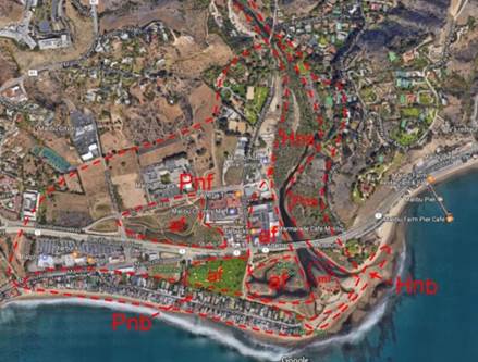
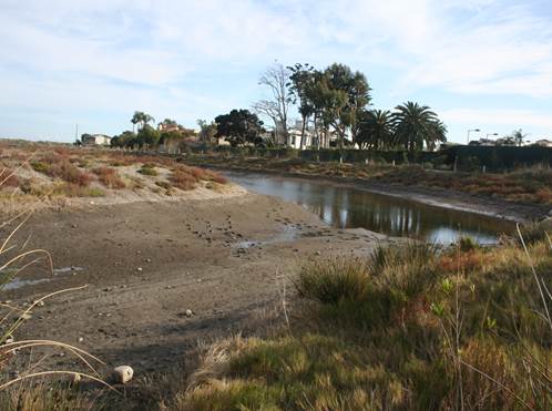
Figure 2. Malibu Creek
Floodplain Photogeologic Map.
af: graded
artificial fill; Hnb: historic bar
sands; Hns: historic braided stream
channel; Pns: prehistoric aggraded
stream channel deposits; Pnf:
prehistoric floodplain alluvium; Pnb:
prehistoric bar sands; mf: persistent
mudflat . Photobase: Google Earth. This
photo is post- 2012 during the open
condition, and post-November 2103.
2.4.1
Shore Processes
The
geomorphic character of the MCF shore is
the result of two interacting hydrodynamic
systems: [i] MCF aggradation which
advances the littoral zone, and [ii]
interacting wave attack and longshore
drift. Together, these processes produce a
sand bar across the mouth of the creek.
When fully developed, it is referred to as
the barrier-bar because it prevents creek
flow from reaching the ocean.
2.4.1.1 Barrier-bar
Destruction and Reconstruction
The
mechanical manner in which the bar is
constructed is not well understood, but it
functions to produce from the longshore
drift sand having a narrow range of grain
size and composed almost exclusively of
feldspar and quartz. Every 10 - 20 years
or so, creek flooding removes much, if not
all of the barrier bar east of the Malibu
Colony. Immediately thereafter,
reconstruction of the bar begins
progressing from west to east. So far as
observed, the bar is completely developed
across the creek mouth within a month or
so.
Since this
mechanism is the result of a dominant
northwest wave regime approaching an
east-west shore, an easterly longshore
drift prevails except for short periods
during the summer when a south swell
prevails. During especially high northwest
swell, sands can be completely removed
from beaches; however, during the summer
when a south swell prevails, sands
offshore are redeposited on the beaches.
2.4.1.2
Bar-breaching Mechanism
No
authoritative record regarding breaching
of the barrier bar has yet been found. It
is understood, anecdotally, that prior to
construction of the Tapia plant, in order
to avoid stagnant conditions in the barred
creek mouth during the summer, the bar was
artificially breached to allow trout to
reach the ocean, and the breaching done at
the western side of the bar, farthest from
the Malibu point right-slide surfing break
so as to minimize surfers direct contact
with the creek outflow waters. Currently,
due to the release of Tapia effluent,
breaching occurs automatically when the
inundated level rises high enough.
As observed
November 19, 2013, soon after breaching
occurred, a channel about 25 feet wide had
been eroded directly through the bar
southward to the shoreline, and in a high
rate of turbulent flow was occurring. That
condition persisted until the inundated
level was reduced roughly to about two
feet or so below the average elevation of
the bars surface. At that time, the rates
of inflow primarily from the Tapia plant
and breaching-channel outflow approached
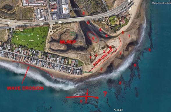
equilibrium. Figure 3 indicates the
complicated interrelationship between
geologic and hydrodynamic conditions of
the creek mouth during this latter stage
open condition.
Figure 3. Malibu Creek Mouth
Composite Geologic/Hydrodynamic
Conditions.
1: initial
breach channel; 2: subsequent breaching
channel; 3: tributary channel to either
3 or 4; 4: second breaching due to
clogging of channel 1, later captured by
channel 5; 5: final position of
breaching channel; 6: mudflats exposed
upon reduction of inundation level; 7:
fine-grained longshore drift; 8:
plunging syncline in stratified bedrock;
9: volcanic reef bottom outcrops. Photo
base: Google
It is
surmised that when the breaching channel
outflow reaches a certain rate, the
longshore drift mechanism becomes dominant
over the power of the breaching channel
outflow at the shore. During this process,
the breaching channel adopts a generally
southeasterly axis diagonally across the
bar until, eventually, at the eastern edge
of the bar it stabilizes against a rip-rap
slope at the base of Vaquero Hill, the
site of the Adamson House compound. The
breaching channel thereafter maintains
that configuration until creek flow
terminates due to the end of the
authorized Tapia-plant effluent dumping
period.
The offshore
queried area in Figure 3 appears to be the
location of a geologic contact separating
a sedimentary section from one of
intrusive bedrock. The mudflat within the
dotted area is a mudflat where sea gulls
and other species are to be found
throughout the year. The selective area of
wave erosion along the Malibu Colony beach
apparently is due to an offshore bottom
condition which, depending on wave
approach direction, focusses wave energy
which interrupts, locally, the longshore
drift.
2.4.1.3 Postulated
Back-bar Channel Development
From
Figure 4, the local stream regimen in most
recent prehistoric time can be inferred.
The pronounced curve of the creek convex
to the west ran through what is now,
approximately, the business district north
of PCH at its intersection with Cross
Creek Road, indicated as MV in the figure.
Boundaries of three channels in or
adjacent to the approximate location of
what is now the MLREP facility also are
shown.
Figure 4.
Rindge Ranch Map Modified from Doyle
and Rindge (2012, p. 61).
Although dated
1931, the base for this map probably was
prepared within a few years after the
Rindge family obtained title to the
Rancho Malibu-Topanga Sequit in 1892.
The encircled letters refer to
improvements added throughout the 1892
1931 period. The general location of the
MLREP facility is encircled. Modified
from Doyle and Rindge (2012, p. 68).
All cultural
features, indicated by the encircled
labels A through F were added to the map
after its initial preparation, as well as
the pumping plant and tanks many years
after 1892 when Frederick Hastings Rindge
obtained title to the Topanga-Malibu
Sequit It seems likely that the map base
was prepared within the period of 1895
1897 and almost certainly prior to 1900.
The
configurations of the creek and channels
1, 2, and 3 of Figure 4 numbered in
accordance with time of formation,
indicate that considerable care was taken
in preparation of the map base. The
configuration of at the western end of
channel 3 suggests either local
concentrations of sheet-flow runoff or,
conceivably, a series of braided channels
fed by an earlier position of the creek.
In any case, it appears that terrestrial
channel flows suggested by the letters c
met the landward base of the existing
barrier bar upon part of which the Malibu
Colony development was later located. From
there, backed-up flows in these channels
reached confluence and the combined flow
then moved eastward along the base of the
bar eventually reaching the creek mouth.
In that process, back-bar channel 3 was
formed. Earlier similar events had formed
channel 2, and channel 1.
Figure 5, from USETA9 Staff (op. cit.,
Fig. 6-7, p. 6-8), shows conditions
somewhat later, probably about 1900, since
actual field work commonly precedes
publication by several years. At that
time, based on channel shape, it appears
that Channel 1 had been filled probably,
it is surmised, for the purpose of
creating additional arable land. At the
time, unless windmills were in use, the
water supply was from the creek.
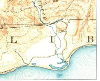
Figure 5.
Part of 1903 U.S. Geological Survey
Calabasas Quadrangle.
This figure is
taken from USETA9 Staff (op. cit.,
Fig. 6-7, p. 6-8). The Rindge railroad
was constructed across the floodplain
just north of the northernmost back-bar
channel about three years later.
It is
reasonable to postulate that this
mechanism of back-bar channel development
has been in progress for thousands of
years possibly beginning almost as soon as
creek flows from the Serra Retreat
meander, Figure 1, began to develop the
floodplain.
2.4.2
UCLA Floodplain Development
Interpretation
A
report by Ambrose and Orme (2000),
commonly called the UCLA study has been
the basis for much of the USETA9 staffs
analysis of the physiographic development
of the Malibu Creek floodplain. While
excellent in certain in certain respects,
the UCLA study suffers from a fundamental
error that of interpreting the creek
floodplain throughout its development as
largely an area-wide lagoon as shown in
Figure 6.
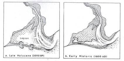
Figure 6. Postulated Lagoonal
Conditions, UCLA Study.
From
Orme, et al. (2000, Fig. 2-1a,
b, p. 2-3).
Such a
condition, both in geomorphic and
hydrodynamic terms, is impossible to
imagine, because it requires the presence
of a single area-wide wetland as late as
the 1800s to be subsequently buried almost
everywhere with the existing substantial
thicknesses of stream alluvium by the time
the Rindges took possession a period of
less than 100 years. Such a process
certainly would require thousands of years
to accomplish. To be fair, this
error in interpretation has little to do
with the overall purpose of the UCLA study
which considers biological conditions. In
fact, seemingly contrary to the idea of a
single, area-wide lagoonal expanse over of
most the floodplain, Orme (2000, p. 1-17)
asserts, somewhat ambivalently, that:
Lower Malibu
Creek and its environs have been the
focus episodic wetlands throughout the
Holocene
Furthermore, a
fair reading of the analysis by Orme (op.
cit., pp. 1-14 1-17; Fig. 1-8) is
the basis for inferring that the Malibu
Creek floodplain is advancing seaward
sporadically. It is clear that this is due
to local tectonic uplift and accompanying
Malibu Creek floodplain aggradation during
which a series of barrier bars were formed
along the seaward advance of the
shoreline.
Nevertheless,
despite the area-wide lagoonal
interpretation of Figure 6 which is
clearly inconsistent with this process of
episodic seaward aggradation, USEPA9 Staff
(op. cit., Sec. 1.3.2, p. 1-4 )
state:
Malibu Lagoon
is located in the City of Malibu, Los
Angeles County at the mouth of Malibu
Creek. The wetland acreage includes 2/3
mile of creek corridor east of the (north
EDM) Pacific Coast Highway (PCH)
and the wetland habitat acreage is
approximately 92 acres. The historic
wetland size has been documented and
estimated to be several times its
present size; the wetland had extended
through the Civic Center area to the
Pepperdine University property.
It seems
clear that this description is based on
the interpretation of the lagoonal
development in the Malibu Creek floodplain
as erroneously postulated in the UCLA
study. Further, in failing to distinguish
lagoonal acreage from wetland acreage it
is unclear if USEPA9 staff regards the
two, if not synonymous, at least having no
significantly different biological
character. This is especially a matter to
consider in view of the fact that TMDLs
apparently are to be applied to the
recently completed Malibu Lagoon
Restoration and Enhancement Facility
(MLREP) as well as, presumably, elsewhere
along the creeks lowermost reach.
* * *
3.0
MALIBU LAGOON RESTORATION AND
ENHANCEMENT PROJECT
All wetlands
are not lagoons, and not all lagoons are
wetlands. Nevertheless, without
qualification, USETA9 Staff (op. cit.,
p. 1-5), in referring to the MLREP state:
Malibu Lagoon
is a valuable coastal wetland. In summer
2012, the State of California, Santa
Monica Bay Restoration Commission, and
CDPR conducted an extensive restoration
of Malibu Lagoon Tidal flow and improved
water circulation are expected to
restore critical habitat for Pacific
Flyway migratory birds and threatened
wildlife.
In considering
the duty of the EPA to define, or have
defined, water bodies worthy of protection
under the Clean Water Act (CWA), and its
authority to define TMDL standards for
certain conditions perceived to
significantly affect water quality, it is
important to understand the character of
the MLREP project as a basis for
determining whether it is properly
regarded as a CWA 303(d) water body.
3.1 MLREP
DEVELOPMENT
LARWQCB Staff
(op. cit., Table 2, p. 3), in
referring to Malibu Lagoon as a feature in
existence in 1998, could only have meant
the mouth of Malibu Creek, i.e.,
the inundated lowermost reach of the creek
to some point upstream. With completion of
the MLREP project, it is clear that it is
regarded as part of Malibu Lagoon, as
discussed below (Sec. 3.5). Consequently,
the proposed subject IP is to consider
TMDL standards for the 2014 MLREP facility
as well as that of the 1998 Malibu Lagoon.
In an attempt to clarify the ETAs
conception of lagoonal area(s) and
wetland(s) in the Malibu Creek floodplain,
it is necessary to consider to some extent
the history of the local area.
3.1.1
Beginning Residential and Commercial
Development
According
to Rockhold (1916, Sh. A3), by about 1914,
most of Channel 2 of Figure 4 remained;
however, unless simply sketched in by
Rockhold, its shape in plan had been
significantly modified from that shown in
Figure 5. At that time, the Rindge Hueneme
Malibu and Southern Railway was still in
place, and the land between it and Channel
2 of Figure 4 apparently was not in use
either as agricultural or pasture land. By
1929, residential development of the
Malibu Colony had progressed
significantly, and the area had been
entirely filled. That fill may have been
materials excavated during construction of
the first Pacific Coast Highway in the
local area over the railway route west of
the MCF. Further use of what is now the
MLREP facility area as a disposal site may
have occurred during the realignment of
present Pacific Coast Highway begun about
1946. In any event, however, it appears
that by 1949 all significant grading in
the area that was to become the MLREP
facility had been completed.
There then
ensued a period from about 1950 - 1983
during which a pathway led through the
project area to the beach, and for some
period, part of the property was used as
Little League baseball fields. At that
time, the adjacent property to the west,
where a private pitch-and-putt course now
is located, was simply abandoned farmland.
3.1.2
CDPR Eco-channels
In the early
1980s, title to the 16-acre MLREP area
passed from the Rindge family to the State
to be administered by the California
Department of Parks and Recreation (CDPR).
In 1983, for reasons not entirely clear, a
system of "eco-channels" was installed.
These led to the southeastern corner of
the site where it met the mouth of Malibu
Creek close to where the western end of
the barrier bar and the eastern end of the
Malibu Colony meet. Those channels
apparently were not based on any formal
hydrodynamic design. By the late 1990s,
they reportedly had deteriorated primarily
as a result of invasive vegetation and
sedimentation.
3.2 MLREP DESIGN AND CONSTRUCTION
It
appears that research for the MLREP
considered no historical data earlier than
1983 and probably was based essentially on
conditions as reported in the UCLA study.
Initially, presumably sponsored by the
CDPR, exploratory planning meetings were
undertaken with representatives of various
public agencies, a technical advisory
committee, a working group, and certain
shareholders. So far as the record
reflects, there was essential, if not
perfect, agreement among all attendees
with regard to what needed to be done, if
not specifically how to do it. The manner
in which such meetings were conducted, and
what minutes or documents, if any, were
prepared is uncertain.
Initially,
however, it was decided to rehabilitate
the eco-channels. It seems likely that the
theory of a widespread lagoonal condition,
as suggested in Figure 6, was the basis
for assuming that rehabilitating the
eco-channels would require simply clearing
them of vegetation and widening and
deepening them. Figure 7 may have been the
basis for the initial proposal to
rehabilitate the eco-channels. Probably,
the rejection of the initial eco-channel
restoration design in favor of the more
straightforward dendritic MLREP design was
based on the assumption that the latter
would be more efficient with regard to
tidal flushing and circulation.
Apparently, in the further belief that
upon equilibrium, the breaching channel
inlet would be close to sea level, the
MLREP channel was to be graded to that
elevation.
Figure 7. UCLA Study Figure
9-4.
3.3 MLREP OPERATIONAL ISSUES
It is
clear from LARWQCB Staff (op. cit.,
Sec. IV.C. p. 37) that the MLREP facility
is regarded as an area where the subject
proposed IP is to be applied. However, a
review of the first MLREP performance
monitoring report prepared for the Bay
Foundation by Abramson, et al.,
(2015), calls into question whether the
MLREP facility is an appropriate area for
the EPA concern.
Upon
completion of the MLREP facility in June
2013, two issues were immediately
presented. One is whether the Bay
Foundations application of the California
Rapid Assessment Method (CRAM) for
evaluating wetlands is appropriate. The
other is whether the manner in which MLREP
algae has occurred is significant.
3.3.1
Questionable CRAM Analysis
As
a condition of Coastal Commission
approval, periodic physical monitoring of
the MLREP facility and application of the
California Rapid Assessment Method (CRAM)
was required. The fundamental purpose of
CRAM analysis is to provide inventories of
wetland species and wetland conditions in
applicable "assessment areas" (AA). The AA
is a wetland sufficiently isolated from
its surroundings so as to be reasonably
assured that any changes in its physical
and biologic characteristics are natural,
i.e., unaffected by artificial
conditions. In CRAM analysis, various
conditions are noted empirically and
recorded in special forms to assure
temporal and physical consistency. From
such form entries, algorithms are used to
convert observations to numerical scores
by which trends in conditions can be
quantified.
Aside
from the question of whether the MLREP
facility is a wetland, the ostensible CRAM
as applied by Abramson, et al. (op.
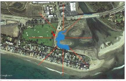
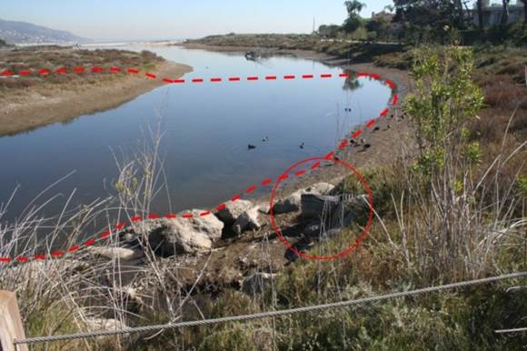
cit., pp. 4 - 7), shown in Figure 8,
raises questions regarding both the
physical character of the asserted AA and
what are referred to as buffer zones.
Figure 8. MLREP Facility CRAM
Assessment Area.
The blue area
is a CRAM AA according to Abramson, et
al. (ibid., Fig. 3, p. 6).
The red arrow gives the position and
view direction of Photos 1-6.
3.3.1.1
Inappropriate
Assessment Area
In
Figure 8, the area in blue, presumably
defined by Bay Foundation personnel as an
AA, includes sections of MLREP channels in
which, during open conditions, extensive
areas of channel bottoms are exposed. The
orange buffer lines are drawn through
areas presumed to be buffer zones. In the
figure, the red arrow points
south-southeast from MLREP facilitys
western observation platform just north of
the MLREP facilitys bird blind.
Photo 1.
Headwater, Southernmost MLREP Facility
Channel.
The raised
area, left, is part of the MLREP
facilitys westernmost avian island.
View, ESE; photo: EDM, 01/20/16, 16:03
hrs.
3.3.1.2
Ineffective
Buffer Zones
A
buffer zone is an area abutting a wetland
which, because of its physical character,
protects it from external conditions that
would interfere with the manner in which
it functions naturally. Even if a
CRAM-like assessment were applied to the
blue area of Figure 8 as a means - other
than with regard to hydrophyte development
as a means to judge the MLREP facilitys
environmental significance in terms of the
subject proposed IP TMDLs, the results
would be questionable because of the lack
of effective buffer zones. Clearly, the
arbitrary boundary along the eastern side
of the blue area of Figure 8, where there
is direct hydraulic continuity with
adjacent channel sections, cannot function
as a buffer zone.
Aside
from this, possible point source of
contamination represented by the culvert
outlets shown in Photo 2, and the
suggestion from Figure 8 that lands
adjacent to the MLREP on its northern,
western, and southern sides are adequate
buffer zones overlooks the fact that
ground-water gradients to the MLREP
facility from both the north and the south
carry in dissolved solid constituents from
on-site water-water disposal systems, and
similarly, from the pitch-and-putt course
to the west, constituents derived from
fertilizers all point sources of
contamination of some sort.
Photo 2.
Asserted CRAM AA, MLREP Facility
Southernmost Channel.
Dashed line
indicates the approximate boundary,
south end of CRAM assessment area of
Abramson, et al. (2016). Outlets
of two culverts encircled. View east;
Photo: EDM, 1/17/17, 13:02 hrs.
Consequently,
varying
ranges of nutrients and various chemical
constituents entering the MLREP facility
waters certainly should call into question
the significance of the Bay Foundations
so-called CRAM scores as reported by
Abramson, et al. (op. cit.)
and hence their relation to the
determination of nutrient TDMLS for the
MLREP facility.
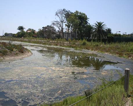
3.4 ALGAE OCCURRENCE ISSUE
Unaccountably,
Abramson, et al., (op. cit.,
p. 60) in reporting that:
post-restoration
cover data were dominated by wrack, or
floating/detached marine kelp species, and
after two years, still remained below a
10% total cover range and well within the
success criteria recommendations ,
do not mention
the astonishingly extensive algal blooms
that developed throughout the MLREP
facility immediately after its completion.
As observed from the west observation
platform of the MLREP facility, Photos 3 5
illustrate that condition. The coverage,
or "wrack," of those mats was then near
100 percent in some of the channels, and
overall, throughout the MLREP facility,
such coverage was roughly 60 - 80 percent
at times during the summer seasons of 2013
and 2014. However, beginning quite
abruptly about the middle of September
2014, as shown in Photos 6a and 6b, the
blooms disappeared have not occurred
since. The unanswered question is: Why?
One
way to prevent algal blooms is to add an
algaecide such as copper sulfate. Whether
the MLREP facility waters have been
treated in some such manner is uncertain,
but no other explanation of the current
absence of such blooms presents itself at
this time. If, indeed, an algaecide is in
use, its effect on benthic individuals
certainly should be considered. Until it
is determined whether the MLREP facility
waters are being treated, and if so, the
effect on is benthos, it seems premature
to assign it any TMDL standard.
Photo 3.
Southern Part, MLREP Facility CRAM AA.
This view is
taken from roughly from position as that
of Photo 2. View, ESE; photo: EDM,
08/06/13, 15:24 hrs.
Photo 4.
Algal Mat, MLREP Southern Channel
This view is
taken from roughly from the same
position as that of Photo 3. View, ESE;
photo: EDM, 09/17/13, 11:23 hrs.
Photo 5.
Algal Mat, MLREP Southern Channel
This view is
taken from roughly from position as that
of Photo 3. View, ESE; photo: EDM,
08/14/14, 11:22 hrs.
|
|
|
|
|
 |
|
 |
|
|
a
|
b
|
Photos 6ab. Foregrounds,
Southern Area of MLREP CRAM AA.
Photo 6a, left.
MLREP west observation platform, View E,
photo: EDM 09/29/15, 13:26 hrs. Photo
6b, right. MLREP south channel
headwaters. View E.; photo: EDM,
09/29/15, 13:27 hrs.
3.5 TMDL APPLICABILITY ISSUE
According
to LARWCB Staff, (op. cit., Sec.
IV.C. 6), there is a need for TMDL
standards for the "Malibu Lagoon
Restoration," by which may be meant either
the MLREP facility, or the creek mouth, or
both. Staff has assumed, in referring to
the earlier eco-channels, that the MLREP (op.
cit., p. 37) has:
"...
re-contoured
the western channels to improve water
flows and circulation ... (and) ...
creating several acres of new wetland."
Clearly, the
extent to which TMDLs for nutrients and
hence sedimentation should be deemed
appropriate rests upon whether this
characterization of the MLREP facility is
accurate. In fact, it is not.
3.5.1
Absence of Wetlands
Utilizing
CWMW, 2012, Abramson, et al.
(2015) present the Bay Foundations
interpretation of the MLREP AA shown in
Figure 8. As shown in Photo 1, it includes
a section of MLREP facility channel that
is exposed during the open condition. From
this evidence alone, according to accepted
wetland definitions (Sec. 1.4.2.8), the
area to which CRAM analysis has been
applied cannot be a wetland, and hence not
an AA, because it is devoid of
hydrophytes. Photo 1 shows a typical MLREP
facility channel bottom condition.
Lacking
a definition of "wetlands" in any of the
works associated with the design of the
MLREP facility, or in the recently
completed monitoring report by Abramson, et
al. (op. cit.), reference
here is to that of the Wetlands Training
Institute (1995) as quoted above (Sec.
1.4.2.8). Accordingly, no wetlands have
been created by construction of the MLREP
facility. This assertion is based on
numerous observations during open
conditions which invariably show exposed
channel bottoms essentially devoid of
hydrophytes or any other type of
vegetation. This condition has persisted
since its completion. Therefore, because
the sine qua non of a wetlands
is:
"...
a
prevalence of vegetation typically adapted
for life in saturated soil conditions..."
(Sec. 1.4.2.8, above),
the lack
thereof anywhere in the MLREP facility
demonstrates, unequivocally, that it is
not a wetland.
Unless
for some unspecified reason Abramson, et
al. (op. cit.) can show that
areas that do not support hydrophytes
should nevertheless be considered
wetlands, it is difficult to understand
how the MLREP facility can considered be a
water body suitable for TMDL assignment
and hence a subject for the proposed IP.
Since
the Bay Foundations asserted CRAM AA lacks
hydrophytes and hence, by definition,
wetland status, the significance of
whatever benthic organisms may reside
there is questionable. MLREP facility
channel bottom are simply mudflats
constructed artificially.
3.5.2
Lack of MLREP Circulation
From
the beginning of MLREP planning, a major
selling point, so to speak, was that
better circulation was necessary to
restore the original health of the project
area "wetland." Nevertheless, aside from
the fact that the project area, per se,
was never a wetland, water in the MLREP
facility channels, like that in the
eco-channels they have replaced, does not
circulate.
During
the closed condition, the static level in
the MLREP channels is the same as that in
the impounded creek mouth, and there is no
flow because the hydraulic gradient is
effectively zero. On the other hand,
during the open condition when, several
weeks after the breaching channel flow is
essentially at grade with flow probably in
the range of 30 - 60 gallons per minute,
floating objects in the MLREP facility
interior remain stationary indicating the
absence of current flow except in the
immediate vicinity of its boundary with
the creek mouth close to the intake of the
barrier-bar breaching channel.
It
is apparent that drainage from the MLREP
facility during the open condition is much
like that of tank drainage essentially
like that of a bath tub in which the
surface simply lowers without lateral
translational movement as the volume
decreases. In other words, during drainage
to reach and maintain open condition
equilibrium flow, there is no current flow
and hence no circulation over almost the
entire expanse of the MLREP facility,
because, as with the closed condition,
there is no effective hydraulic gradient.
In
such circumstances, there arises the
question of whether assigning TMDLs is
appropriate to an area such as the MLREP
facility the hydrodynamic character of
which is yet to be understood. Salinity
measurement such as those of those of the
initial series reported by Abramson, et
al. (2015, pp. 24-25) for eight
MLREP facility stations, during the period
of February 14, 2013 - December, 23, 2014,
if made frequently, might be quite useful
in this regard.
3.5.3
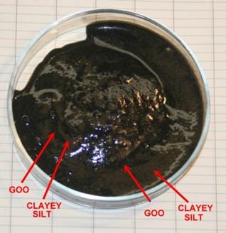
Black Goo
Almost
everywhere in the interior area of the
MLREP facility, channel bottoms appear to
be covered with a somewhat cohesive and
gelatinous organic substance conveniently
described here as black goo. It occurs as
a distinct stratum overlying saturated
inorganic deposits such as clayey silt
with which it remains immiscible unless
disturbed. Its thickness is about 0.5 1.0
inches close to shores but perhaps more
elsewhere. Laboratory specimens have a
slight hydrogen sulfide odor. When
thoroughly mixed manually and allowed to
stand, it does not separate; however, as
shown in Photo 7, with slight mixing the
separate masses remain immiscible.
The
extent of the black goo, as judge by its
occurrence in exposed channel bottoms,
probably is present everywhere in the
MLREP facility channels. This is
consistent with the supposition that it is
the settled residuum of algae that has
been treated with an algaecide. An
algaecide such as copper sulfate might
explain the goos hydrogen sulfide odor. As
a matter of speculation, the goo may the
result of the type of enzymatic bacterial
organic decomposition believed to be an
early-stage reaction forming bitumen.
Most
relevant for present purposes is the
question of whether the goo is either
toxic or otherwise harmful to benthic
organisms. Whether or not such, however,
its possible effect simply as a physical
barrier to overlying waters such that
benthic organism exhaust dissolved oxygen
seems worthy of investigation. The results
of such investigation certainly should
precede a determination of whether the
MLREP facility is an appropriate ETA water
body.
Photo 7.
MLREP Black Goo and Clayey Silt.
Sample
collected close to shore just west of
the south observation point.
*
* *
4.0
SEDIMENTATION
Sedimentation
as a basis for assigning TMDLs in the MCDA
is especially troublesome. The extent to
which the biological importance of
sedimentation is here left to others.
Rather, concern for present purposes is
with regard to the physical character of
the sedimentation process. A fair reading
of USEPA9 Staff (op. cit.)
especially Sections 8.1.5, 9.2.1, and
9.23, together with Tables 8-3, 8-4, 8.14,
and 8.15, indicates that there is,
essentially, a presumption of benthos harm
due to sedimentation based on the on a
statistically questionable period of 2000
2011 during the latter half of which there
was severe drought. However, the treatment
of the subject in mechanical terms also
raises issues of sedimentation as a
significant benthos stressor in the MCDA.
4.1 MCW SEDIMENTATION
The dynamic
character of the various MCW streams
should be the primary criterion for
determining whether sedimentation TDMLs
are necessary or, in fact, even possible,
let alone feasible. Although many streams
in California have similar characteristics
permitting reasonable inference concerning
similar conditions in different streams
that nevertheless affect their benthos
communities and their habitats similarly,
such is almost certainly not a true of
MCDA because of its unique dynamic
character. For further consideration in
this particular regard, refer to Section
5.2.1, but for now, however, attention is
directed to sedimentation with respect to
MCW hydrodynamic conditions.
4.1.1
Questionable Presumption of Benthos
Habitat Harm
Assumption
that sedimentation is an MCW stressor
requiring a TMDL standard appears to stem
primarily from a series of observations
reported by Sikitch, et al. (2013).
The organization and illustrations of that
report, available on the web, is
admirable; however, to consider its
significance fully, its appendices, which
are not available on the web need to be
considered. Contact with Heal the Bay on
March 10, 2017 for directions on how to
obtain the appendices has so far been
unavailing.
However,
without regard for statistical aspects of
benthos observations, the significance of
the bioscores for the California Stream
Index and Ratio of Observed and Expected
Taxa data reported by USETA9 Staff (2013,
Table 8-14), mostly reported by Heal the
Bay for some eighteen sites, is
suggestive. For the period of 2000 2010,
reported bioscore reductions begin in
either 2005 or 2006 and continue through
that period. The fact that such reductions
coincide with the advent of the recent
severe drought strongly suggests a
relationship between benthos survival and
stream surface flow, or ground-water flow,
or both.
Nevertheless,
USETA9 Staff (op. cit., pp.
10-3 10-8), in support of the asserted
need to assign sedimentation TMDLs for the
MCDA, state (op. cit., Sec. 10.2):
the excess
movement and deposition of sediment is a
critical problem in Malibu Creek, its
tributaries, and the Lagoon
Similarly, (op.
cit., p. 9-31):
(T)he strength
of evidence supporting the causal
pathway between urban runoff and
increased sedimentation is strong ,
Nevertheless,
no specific data are offered demonstrating
exactly how sedimentation in the MCDA is
harming benthos even generally, let alone
strongly or critically, or in what
specific areas such problems exist.
Rather, this seems to be based simply on
the idea that sedimentation equals benthos
harm, i.e., subjective evaluation
rather than documentation.
4.1.2
Questionable Inferred Surface Runoff
In
support of the thesis that increased
sedimentation in the MCW is due to
increased development, USETA9 Staff (op.
cit., p. 9-30) state:
Using
the
Simple method rule (Caraco et al., 1998)
the impervious land generates surface
runoff relative to pervious land in a
ratio 0.95/0.05, impervious surfaces were
estimated to yield about 59 percent of the
surface runoff in the watershed.
Caraco, et
al. (op. cit.) give no such
ratio; rather they refer to an give an
appendix purporting to apply the Simple
Method of Schueler (1987). However, using
the impervious area fraction of 0.0695
(USETA9 Staff, ibid.), and a mean
annual rainfall of 12 inches, gives an
annual runoff of 1.2 inches, whatever that
means. To verify the applicability of the
0.95/0.05 rule to the MCW, the
calculations of the USETA9 Staff need
review.
In any event,
brief perusal of the Schuler method as
assertedly employed by Caraco, et al.
(op. cit.) shows the that
the 0.95/0.05 rule has been applied to
five local and largely developed test
areas of the Atlantic seaboard and
immediately adjacent lands having no
climatic, geologic, or topographic
conditions remotely similar to the MCW. It
therefore is difficult to imagine how
USETA9 Staff could reasonably regard the
0.95/0.05 as applicable.
 4.1.3
Observations of ETA Regional 9 Staff and
Staff Scientist Harrington 4.1.3
Observations of ETA Regional 9 Staff and
Staff Scientist Harrington
According
to USETA9 Staff (op. cit., Sec.
2.2.1, p. 2-6) Staff Scientist James M.
Harrington of the California Department of
Fish and Game has stated that in his
opinion several major tributaries in the
Malibu Creek Watershed show typical signs
of ecological impairment due primarily
sediment. However, since it also is
recognized (op. cit., p. 2-7) that:
(T)here
are
many other potential causes of the poor
IBI scores (including excess nutrients,
metals, organics, and exotic species,
the
basis for focusing on sedimentation as a
causal stressor is not apparent.
Further, in
considering the dynamic conditions
regarding sedimentation in that:
(M)ost
of
the sediment mass moving through Malibu
Creek leads to filling of natural pools
and clogging of substrate, and then moves
as bedload during major storm events
(op. cit.,
p. 10-3), and accepting such observations
as accurate locally, it nevertheless, is
hardly probative of whether they have any
significance, per se, regarding
significant benthos harm, if any. For such
remarks to be taken as significant with
regard to the need for sedimentation
TMDLs, the supporting data that were
reviewed must be specific in terms of
locations and periods observations if they
are to be accorded scientific validity. In
view of such generalities, is difficult to
see any basis whatsoever for concluding,
without more, that TMDLs, let along
related IPs, in the MCW would be
meaningful.
More to the
point, flooding great enough to result in
channel scouring occurs fairly often in
the MCW, say every 10-20 years. Even
assuming that sedimentation during the
above specified 5-year period is
representative the entire MCDA, it cannot
have any statistical significance
regarding the manner in which
sedimentation is expected to occur in the
future. Such data have no predictive value
whatsoever and clearly cannot be a
rational basis for an implementation plan
to protect benthos habitats.
Again
lacking sufficient observations to
determine a representative statistical
sedimentation rate for each MCW stream of
concern, the fact that it is observed that
certain natural pools become filled, and
certain substrates become clogged before
being scoured away is hardly significant
in relation to a TDMLs for other such
systems. Nevertheless, it appears that
serious consideration is being given to
protecting such pools and substrates from
excessive sedimentation, all assuming that
such features house benthos needing
protection.
4.1.4
Comparative Observations Asserting
Sediment Accumulation 1983 - 1987
Accepting as
accurate the report that for the MCDA:
(M)easurements
of
sediment in 1987 suggested that the
average rate of sedimentation since 1983
was 10 cm/year (and) estimated to be
nearly ten times the rate that would have
occurred in pre-European settlement
periods (op. cit., Sec. 8.2.3, p.
8-60),
it is unclear
how such a comparison is relevant to any
need for sedimentation TMDLs, in the MCW
or anywhere else for that matter.
4.1.5
Postulated Effective Work Model of
Bedload Movement
The
concern and hence the need for TMDL
standards for pools and substrates, or at
least some of them, in some MCW streams,
that are being moved by creek flow during
a major storm appears to be predicated on
the idea that the habitats are somehow
transported en masse from one
position in a stream reach to another
downstream. USETA9 Staff (op. cit.,
Sec. 10.2.1, p. 10-2), although lacking
MCW historical data or data from
comparable watershed, nevertheless state:
a reasonable
sedimentation rate to protect the health
of the Malibu Creek Watershed is
determined by evaluating the natural
capacity of flow to move sediment the
Malibu Creek watershed.
The thought
here seems to be that: [i] since excessive
sedimentation can adversely affect
watershed benthic habitats, and [ii] the
natural capacity of a watershed to move
its sediment is diminished by excessive
sedimentation, therefore, [iii] evaluating
that capacity is a measure of watershed
health. Without qualification, however,
the quoted statement is pointless -
nothing more than a truism. Nevertheless,
this kind of thinking is offered as the
basis for assigning TMDL standards for
various streams in the MCW.
Aside from
the fact that thus far data are lacking
indicating actual MCW habitat harm in any
measured degree over a significant period
is related to a demonstrated rate of
sedimentation for that period are lacking,
the natural capacity of flow to move
sediment in the Malibu Creek watershed
needs discussion. Such a statement seems
to assume that for the MCW, habitat harm
is a meaningful function of the capacity
of the MCW relationship to move sediment.
The idea that
sedimentation is a critical problem for
benthos habitats in MCW tributaries, as
presented by USETA9 Staff appears to be
essentially subjective. simply subjective.
Nevertheless, in an effort to show how
anthropogenic activities exert change in
the natural capacity of a stream to move
sediment, and hence is significant for MCW
benthos communities, USETA9 Staff (op.
cit., Sec. 10.2.1, p. 10-3) direct
attention to a 1948 paper by Meyer-Peter
and Muller - and a modification of it in a
2006 paper by Wong and Parker - that
purport to describe an effective work
model of bedload mass transport
downstream. Presumably the thought is that
such a mechanism would be affected by
sedimentation, and hence in turn affect,
somehow, the health of whatever benthic
communities are housed therein, and
thereby USETA9 Staff implies, reasonably
enough, that the MCW benthos health would
be adversely affected. Regardless of the
fact that:
(S)ufficient information was not available
to complete such an analysis for Malibu
Creek watershed , (ibid.)
the question
to be addressed here is whether - under
any circumstances - an effective
work model is relevant to the health of
the MCW as is unequivocally asserted, to
wit:
the health of the Malibu Creek Watershed
is determined by evaluating the natural
capacity of flow to move sediment in the
Malibu Creek Watershed (op. cit.,
p. 10-2).
However,
no scientific whatsoever is presented to
support this statement.
On its face, the idea that effective work
applies to stream bedload movement is
questionable, because - aside from
coherent cobbles and boulders - it
requires that a force due to flowing water
can be applied, bodily, against a discrete
bedload mass. It seems clear that what is
postulated is a block of bedload material
capable of moving as a unit due to the
driving force derived from stream velocity
and channel slope together acting in such
a manner that it overcomes the resisting
critical shear stress (op. cit.,
Sec. 10.2.1, p. 10-2), i.e., the
strength resisting sliding, that must
exist between a postulated block and the
underlying channel bedrock. Such strength,
of course, would be a function of the
buoyant weight of the block and the
coefficient of friction between the base
of the block and the channel bedrock.
Such a model is not even approximately
representative of natural stream
conditions. A sediment mass in a channel
does not present surfaces upon which the
water can push no matter how great the
flow velocity. Such masses do not move as
discrete, coherent blocks but rather as
incoherent granular masses with no
cohesive strength and very low internal
and basal surface shear strength. If fact,
it is well established that typical stream
bed load masses move more or less
according to the Hjuldstrm model.
4.1.6
Hjulstrm Stream-flow
Model
Generally, it
is well understood that during stream flow
of a sufficient velocity rate, grains are
entrained or floating in the flow.
Similarly, larger grains of a certain size
and shape bounce along the bottom in the
process referred to as saltation, and
still larger grains too heavy to float or
be bounced, are being pushed downstream
along the surface of either the bed
materials or the channel bottom, in the
process referred to as traction. Given the
seasonal and artificial changes in the
flow rate known to occur in the MCW, as
well as the range of artificially induced
gradients in the various stream reaches,
the idea that, somehow, there exists an
environmentally meaningful stream capacity
for moving bedload downstream, except in
the most general, cumulative sense, is not
only questionable, but probably impossible
as a practical matter to demonstrate. Nor
does such a datum seem relevant in terms
of benthic habitats considering the fact
that periodic flooding strips some stream
reaches of all bed load masses and
radically disturbs others to such an
extent as to destroy all benthic habitats
and probably the organisms therein.
Figure
9 is one version of the Hjulstrm stream
transport model relating grain size and
movement to stream velocity. Even though
unrelated to grain mass and shape, the
model effectively describes the manner in
which a stream functions for a wide range
of conditions with regard to its load.
There is no reason to believe that this
model is inapplicable to the flow regimen
of the MCW.
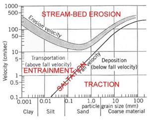
Figure
9. Modified Hjulstrm
Diagram.
The
Hjulstrm diagram also is useful to explain
the cut-and-fill mechanism resulting in
the braided stream phenomenon common in
such areas as the MCF. With reduction in
velocity, saltation is lessened and
entrainment of grains of sizes below the
fall velocity curve are deposited. The
more sudden the reduction in velocity -
which can occur almost instantaneously -
the greater the mass that is deposited. It
is this phenomenon that results in sudden
channel clogging followed necessarily by
lateral rerouting of the channel during
subsequent flows to create the braided
streamflow pattern.
4.2 MLREP FACILITY SEDIMENTATION
Given
the essentially artificial character of
the MLREP facility, its environmental
value seems seriously in question
physically if not legislatively. As a
recreational asset, it certainly has
value, but to establish for it some TMDL
sedimentation standard - thought to
encourage whatever benthic community it
may support - seems difficult to justify.
At least until the effect of the black goo
on benthic organisms is determined, the
value of maintaining a certain
sedimentation TMDL standard certainly is
questionable.
Considering
the low surface gradients of areas
adjacent to the MLREP, sedimentation rates
must be so low that from the recreational
point of view, the value of the MLREP
facility as an avian refuge requiring
little or no maintenance and certainly no
sedimentation TMDL standard, or simply as
an aesthetic resource, can be maintained
by occasional dredging.
* * *
5.0
CONCLUSIONS
It appears
that any reduction in an MCDA benthos
community is arbitrarily regarded as due
to artificial rather than natural
stressors, and therefore bad. This
the-more-the-merrier approach not only to
benthos, but to organisms generally, seems
to characterize this aspect of the
environmental movement. In effect, it
amounts to philosophical rejection of
natural selection and predation as
environmentally significant coupled with a
sort of conceptual nirvana however
unrealistic or impossible a restoration to
some condition never observed nor actually
demonstrated to have existed.
The USETA9
Staff report (op. cit.), despite
its valuable format presenting much useful
data, is nevertheless to a significant
extent erroneous in terms of its physical
conception of the MCDA. Until that is
better understood, assigning TMDL
standards for nutrients and sedimentation
is premature, probably meaningless, and
certainly wasteful.
5.1 MCDA
UNIQUE ENVIRONMENTAL CHARACTER
The MCDA is
an absolutely unique hydrodynamic and
geomorphic feature in California; as such,
TMDLs for it cannot be based reliably on
analogy to other drainage areas except
possibly as applied to certain very
limited processes. Other streams and water
bodies along the California coast are due
to conditions sufficiently dissimilar to
those of the MCDA that to simply assume
their benthic community characteristics
are comparable is scientifically
inappropriate.
For example, in discussion regarding
benthos in Malibu Lagoon to be expected in
the future USETA9 Staff state (op. cit.,
Sec. 3.2, p. 3-3):
based on our
review of other coastal estuaries, we
should expect to see a doubling of the
species and taxa richness within a ten
year time frame. Our best example and
most comparable coastal estuary in size
and physical behavior is Los Peasquitos Lagoon
which is
clearly inadvisable. Los Peasquitos
Lagoon, at the northern side of Torrey
Pines State Park in San Diego County, is
in the seaward most reach of the Los
Peasquitos Creek floodplain. The
floodplain is roughly rectangular with an
area of about 250 acres, and it exhibits a
dendritic drainage pattern. Upstream from
its floodplain, locally meandering Los
Peasquitos Creek and its upstream
extension, Poway Creek, reach
northeastward some 15 miles through
lowlands, about 80 percent of which is
residentially densely developed to its
entirely artificially modified headwater
area in Poway Mesa.
In contrast,
the lowermost 0.8-mile reach of Malibu
Creek - and whatever part of that reach,
if any, that may be legitimately regarded
as lagoonal - is a floodplain of about 50
acres with a distributary drainage
pattern. Upstream, the creek passes
through about 4 miles of essentially
undeveloped mountainous terrain and
beyond, about 7 miles of partly
mountainous and partly mature topography,
only locally developed. Consequently, it
is difficult to see how conditions in the
two areas are so similar as to be a basis
for predicting future benthos conditions
in one in any way relevant to those in the
other.
All in all,
the work concerning the MCDA to date
demonstrates the need for a lengthy period
of study certainly a period of years -
during which the climatic record is
reasonably representative of decadal or
duodecadal change necessary to determine
whether there is significant benthic
impairment.
5.2
QUESTIONABLE RELEVANCE OF SEDIMENTATION
TMDLS
As presented
by USEPA9 Staff, concern about MCDA
sedimentation is especially worrisome. It
seems to be essentially a solution in
search of a problem. There is merely a
presumption of habitat harm resulting from
sedimentation based on what amounts to
preliminary observations rather than firm
scientific analysis. Insofar as the record
reviewed indicates, neither the necessity,
nor the feasibility, of a meaningful TMDL
standard for MCW sedimentation has yet
been demonstrated. In waters either
isolated or otherwise protected from
hydrodynamic effects of normal stream
flow, sedimentation from point sources
probably could usefully be controlled, but
it is obvious that the dynamic character
of the various MCW streams should be the
primary criterion in determining whether
sedimentation TDMLs are feasible.
The idea that
there exists one or more reaches of Malibu
Creek or one of its tributaries where
sedimentation conditions are so meaningful
as to require a TMDL standard to avoid
impairment of benthic communities should
be preceded by a survey of such
communities during periods the include
including flooding and a reasonable range
of climatic conditions. The effective-work
model of bedload movement, at least as
presented thus far, is mechanically
impossible. Without more, the extent to
which it is inconsistent with the
straightforward and readily observable
Hjulstrm model, it should be discarded.
5.3 MLREP QUESTIONABLE ENVIRONMENTAL
SIGNIFICANCE
It is
to be understood that the MCF -
particularly with regard to its so-called
lagoonal character, generally, and that of
the MLREP in particular as discussed in
USETA9 Staff (Sec, 1.3.2) is to great
extent erroneous. This is primarily
because it is based on the UCLA study
which postulates a floodplain-wide wetland
and/or lagoonal condition, as illustrated
in Figure 6, a condition that never
existed. Before TMDL standards are applied
to the MLREP, the following should be
considered regarding whether it is a water
body eligible for CWA 303(d) protection.
5.3.1
Fundamental Issue of Environmental
Planning
The extent to which the MLREP
illustrates a problem in environmental
planning is best demonstrated by fact that
- beyond sponsoring agencies support - the
MLREP facility according to RWQCB Staff
(2016, pp. 37-38) it based on the combined
efforts of:
Heal the Bay, and California State
Department of Parks and Recreation, the
Malibu Lagoon Technical Advisory
Committee, the Malibu Lagoon Restoration
Working Group, as well as numerous other
city, county, and state agencies
and as a result, it is asserted that the
completed project is a restoration that
has:
re-contoured the western channels to
improve water flows and circulation
creating several areas of new
wetlandswhich should help improve the
Lagoon conditions for the benthic
community. (ibid.)
The extent to which this description of
the completed MLREP project is fallacious
is of immediate interest.
5.3.2
MLREP Design Defects
Although the
open dendritic design of the MLREP
facility is a great improvement over that
of the 1980s eco-channels, at least in
terms of recreational value and apparently
conditions for some avian species, it does
not perform as advertised, and is in no
sense some sort of restoration. The MLREP
is based entirely on an erroneous
conception of the MCFs hydrodynamic
character, and it therefore cannot respond
in the manner planned. The question of how
such an impressive collection of planning
talent could have produced the
hydrologically dysfunctional MLREP
suggests its greatest value is that of an
object lesson in how environmental
planning can go awry in the presence of
unfettered political correctness.
5.3.2.1 Wetlands
Fallacy
The idea that
the MLREP area is a restored wetland and
should be treated as such is nonsense. It
is an entirely artificial facility.
However, aside its recreational value, it
does seem to serve to some extent as an
avian refuge, and it might very well serve
as an outdoor laboratory for the study of
benthic communities under stress. Since,
according to accepted definitions, neither
the MLREP facility per se, nor any
part of it is a wetland, attempts to apply
CRAM analysis to it are meaningless. It is
simply a system of artificial of channels
which during the closed condition are
inundated and during the open condition
have partially exposed bottoms best
described as mudflats.
5.3.2.2 Lack of
Circulation
Waters in the
channels of the MLREP facility do
not circulate in the accepted sense of the
term, i.e., by circuitous flow;
rather, they drain and receive waters in a
manner involving some sort of mass
transfer and replacement that is not
understood. Flow in the MLREP only occurs
locally at the eastern edge of the project
when the barrier bar is breached. Although
a change in volume occurs as a result of
the change from the closed to the open
condition and presumably vice versa
flows in the interior of the project do
not occur. The lack of circulation
represents a condition so unrelated to the
natural environment that the character of
whatever benthic communities exist there
is probably environmentally meaningless.
5.3.2.3 Black Goo
The black goo
in the MLREP facility channel bottoms
appears to be an unnatural substance the
origin and chemical character of which
needs to be determined as a first step in
assessing the facilitys character as CWA
303(d) water body. In particular, its
relationship to the occurrence of algae
needs to be determined. Because of the
extent and either its physical or chemical
effect, the goo present a condition
possibly so unnatural that the character
the local benthos, however interesting,
would seem to be environmentally
irrelevant.
* * *
References
Abramson Mark,
Karina Johnston, Ivan Medel, Rosi Dagit,
Dan Cooper, and Rod Abbott, 2015, Malibu
Lagoon Restoration and Enhancement
Project Comprehensive Monitoring Report
(Year 2): The Bay Foundation rpt. for CA
Dept. Parks and Recreation, June 9.
Ambrose,
Richard F., and Antony R. Orme, 2000,
Lower Malibu Creek and Lagoon Resource
Enhancement and Management, Univ.
California, Los Angeles final rpt. for
California State Coastal Conservancy,
May.
Ambrose,
Richard F., and Johnathan Lilien, 2000,
Ch. 8, Management Alternatives in Ambrose
and Orme (2000).
Campbell,
Russell, B.A. Blackerby, R.F. Yerkes,
J.E. Schoellhamer , P.W. Birkeland, and
C.M. Wentworth, 1996, Geologic map of
the Point Dume quadrangle, Los Angeles
County, California: U.S. Geol. Survey
Map GQ-1747.
Caraco, D.J.,
J. Zielinski, and R. Clayton, 1998,
nutrient loading from conventional and
innovative development: Chesapeake
Research consortium, Center for
Watershed Protection, Ellicott City, MD.
CWMW, 2012,
California Wetlands Monitoring Workgroup
Users Manual, Ver. 6.0, Mar. 94 pp.
Dibblee, Thomas
W., Jr., 1992, Geologic map of the
Calabasas quadrangle, Los Angeles and
Ventura Counties, California: Dibblee
Geological Foundation Map #DF-37.
Dibblee, Thomas
W., Jr., 1993, Geologic Map of the
Malibu Beach Quadrangle, Los Angeles
County, California: Dibblee Geological
Foundation Map #DF-47.
Dibblee, Thomas
W., Jr., and Helmut E. Ehrenspeck, 1993,
Geologic Map of the Thousand Oaks
Quadrangle, Ventura and Los Angeles
Counties, California: Dibblee Geological
Foundation Map #DF-49.
Doyle, Thomas
W., and Ronald L. Rindge, 2012, Malibu
Rails and Roads a Photographic Journey
across Rancho Topanga-Malibu-Sequit:
Malibu Lagoon Museum, Malibu, CA 100 pp.
LARWQCB Staff,
2016, Implementation plan for Malibu
Creek watershed nutrients TMDL (2003)
and the Malibu Creek and Lagoon
sedimentation and nutrients TMDL to
address benthic community impairments:
Los Angeles Regional Water Quality
Control Board Final Report, December.
Orme, Antony,
2000, Ch. 1, Evolution and historic
development in Ambrose and Orme
(2000, pp. 1-1 1-37).
Orme, Antony,
Kenneth Schwartz, Priya Fennemore, Mark
Khulman, and Johannes Feddemma, 2000,
Ch. 2, Hydrologic and
morphodynamics,1997-98 in Ambrose
and Orme (2000, pp. 2-1 - 2-112).
Rockhold, J.E.,
1916, Map showing land to be condemned
for the opening of the new Malibu Road,
Pacific through Coast Hy., Rancho
Topanga Malibu Sequit: County Surveyors
Map No. 8970, Sh. A3.
Sikich, Sara,
Katherine Pease, Sarah Diringer, Mark
Abramson, Mark Gold, and Shelley Luce,
2013, Malibu Creek Watershed - Ecosystem
on the Brink: Heal the Bay Santa Monica,
CA,
USEPA Staff,
2013, Malibu Creek & Lagoon TMDL for
sedimentation and nutrients to address
benthic community impairments: U.S.
Environmental Protection Agency, Region
IX, Water Div. rpt., July 2.
Wetlands
Training Institute, Inc., 1995, Field
Guide for Wetlands Delineation; 1987
Corps of Engineers Manual, Glenwood, NM,
WTI20-1, 143 pp.
Yerkes, R.F.,
and R.H. Campbell, 1980, Geologic map of
the east-central Santa Monica Mountains,
Los Angles, County, California; U.S.
Geol. Survey Misc. Inv. Series Map
I-1146.
* * *
|