| |
|
EAGLE PASS RAVINE ROAD
E.D. Michael
September 15, 2009
|
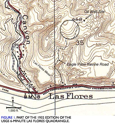
A ravine is a steep-sided channel somewhat larger than a gulch and considerably smaller than a canyon. There are many stream-eroded ravines in slopes of the Santa Monica Mountains in Malibu and elsewhere. On local Malibu maps, some are referred to as canyons, and others are unnamed. I know of none specifically named as a ravine, but one deserving of such is that which has its mouth at Pacific Coast Highway about 2,000 feet east of Las Flores Canyon Road. I have called it Eagle Pass Ravine, because Eagle Pass Drive now passes along a section of its western slope. The route of Eagle Pass Ravine Road is shown in Figure 1.
Sometime prior to 1928, a narrow dirt road was graded from the coast road, then called the "State Highway" and also "Roosevelt Highway," up along the western slope of Eagle Pass Ravine to a wildcat oil-well drilling site. About 1978 when I first visited the area, there was a typical walking beam oil well pump installed just beyond the cul-de-sac of Eagle Pass Drive. Its very presence indicated that at one time there had been some production. The pump had not been operating for some time. It was entirely enclosed by a high chain link fence that at the time I did not feel like climbing to have a better look. I always meant to return with a camera, but before I got around to it some years later, the property had been developed and access to the site was then, as now, barred by a gate fence. Just inside the gate now, there is an odd-looking structure which could house the pump. Even if the pump has been removed, there may still be casing buried at the site. If the pump was removed, specific abandonment procedures that today prevent ground water contamination (CCR, Title 14, Div. 2, Ch. 4, Subch. 1, Art. 3, ¶ 1723, et seq.) may not have been in force at the time. This has significance in terms of conditions today with regard to the Tract 25318 landslide.
The encircled area, added, is approximately where the Tract 25318 was later developed. The line across the beach at BM18 indicates the eastern boundary of the Rindge ranch where, years previously, public access into Malibu Rancho had been closed. Many of the structures shown along the highway and Las Flores Canyon Road roads still exist. The vertical line is the west boundary of Section 35 of Township 1 South, Range 17 West. Except for 448, the well site elevation, texts in italics and the scale have been added.
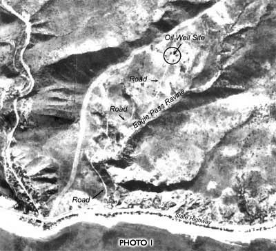
As shown in the figure, Eagle Pass Ravine Road began at the highway a few hundred feet east of Los Flores Canyon Road and traversed up the highway road cut laterally about 1,000 feet to the mouth of the ravine. Grading to widen the coast highway in the late 1940s removed that section of the road. From the mouth of the ravine, the road followed a circuitous route northward some 50 to 75 feet below the present elevation of Las Flores Mesa Drive to a point about 400 feet northwest of Section Number 35 in Figure 1 close to where now, Eagle Pass Drive makes a turn to the north. From there, the route followed closely the present alignment of Eagle Pass Drive to the well site. For geologists and others who find this old stuff especially interesting, Eagle Pass Ravine Road appears clearly in the 1927 Fairchild Aerial Surveys C300 series, exposure J120, a part of which is reproduced here as Photo 1. Even today in aerial photos, much of the roadway is still apparent.
This photo has been modified from the 1927-28 Fairchild Aerial Surveys C300 series, exposure J120. Text has been added. Interestingly enough, the fire-break along the ridge crest between Las Flores Canyon and Eagle Pass Ravine shows that the County, even in these early days, was concerned with brush fires.
Getting trailers loaded with 20-foot sections of oil-well drill pipe and casing up the ravine road must have been interesting. Although there were at least several other exploratory oil-drilling sites in Malibu - one at Point Dume, and two or more just north of Zuma Beach - the well in Eagle Pass Ravine is the only one known to have had production. Since the Marblehead Land Company routinely retained hydrocarbon rights in subdividing and transferring title to parcels, there may be some record of the Eagle Pass well in its files
Landform experts know that "Las Flores Mesa" in Figure 1, including its continuation across the ravine to the east, is not a mesa. Rather, it is the westernmost occurrence of Malibu's coastal terrace. Furthermore, the deposits underlying it rest on a remnant of the marine Dume terrace which at Point Dume was first recognized by William Morris Davis.
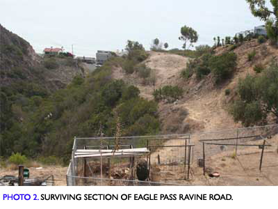
Today, a section of Eagle Pass Ravine Road below Las Flores Mesa Drive, shown in Photo 2, is easily recognizable. An equally well preserved section farther up the ravine extends from the first switch-back of the driveway leading down the slope to 20966 Flores Mesa Drive. There however, the section locally is buried beneath colluvial debris, and otherwise hidden by dense chaparral. Still, from the switch-back, about 1,000 feet of the original alignment can be negotiated on foot if one is careful of snakes and does not mind thick brush.
This view is to the south-southeast from Las Flores Mesa Drive, just south of the driveway entrance to 20966 Las Flores Mesa Drive. To the left is the axis of Eagle Pass Ravine a few hundred feet upstream from its mouth. Photo: EDM, 09/11/09.
The 1920s foray of some wildcatter up Eagle Pass Ravine has long since been overshadowed by the residential development of Tract 25318, and associated with it, landsliding, fire-storm, and redevelopment. And in that context one finds, in microcosm, much of the history of Malibu.
* * *
|
|
|
|


