| |
|
SEA-WATER INTRUSION AND ITS SIGNFICANCE FOR MALIBU
E.D. Michael
November 25, 2009
|
INTRODUCTION
The mechanism of sea-water intrusion has special significance for Malibu. An appreciation for its history and technical character is highly desirable, especially on the part of those who have the responsibility of planning and managing Malibu's environmental future.
It was early recognized that along coasts where terrestrial ground water of low salinity meets ocean water which has a high salinity, that in the subsurface the masses do not mix appreciably but rather maintain an "interface" above which terrestrial ground water is confined in its ocean-ward flow. Because the sea water is denser, it intrudes below the coastal deposits saturated with less dense fresh water. This phenomenon, first reported by Badon Ghijben (1888-1889) and elaborated upon by Herzberg (1901), initially was referred to as the "law" Ghijben-Herzberg. Far from a physical law however, it is best regarded as a model that only roughly approximates real conditions and can be subject to significant error. This condition has been the subject of numerous studies. A particularly detailed series of investigations is that by Cooper, et al. (1964) who demonstrate that the so-called interface: [i] is actually a zone within which there is diffusion of saline water with fresh water; [ii] changes in elevation at depth as a function of the fresh-water head above sea level; [iii] separates fresh water flowing seaward through an upper part of the zone from sea water flowing seaward in the lower part of the zone, both to sections on either side of the shoreline.
The Ghijben-Herzberg model assumes that static conditions prevail along a well defined interface, and consequently at any point along it the fresh-water pressure head is equal to the sea-water pressure head. In such circumstances,
ρf ghf = ρs ghs
where ρf and ρs are the densities of fresh and sea water, hs and hf are the fresh and sea water heads above a point on the interface, and g is the acceleration of gravity. Recognizing that hf is the sum of the fresh-water head, hd , above sea level at any point above the interface, and hs, substitution and cancelling gives,
hd = hs ρs (ρf) -1 - hs ,
Assuming commonly accepted values of density for fresh and sea water as 1.000 and 1.025 grams per cubic centimeter, respectively, gives,
hd = hs (1.025 - 1),
or,
hs = 40 hd .
Consequently, in any well or piezometer penetrating the interface, a value of hd multiplied by 40 gives hs, the distance below sea level to the interface at that location. To determine the distance to the interface below the ground surface at the well, it is of course necessary to know the surface elevation at the well above sea level.
However, Hubbert (1940, pp. 924 - 926) seems to have been the first to recognize that conditions in the aquifer are not static, because both the fresh and saline ground waters are moving everywhere, including through the zone of diffusion to the ocean. This means that any point in a coastal section penetrated by a well or piezometer gives a value, h, which is on an equipotential surface generated by the fresh-water movement. Therefore, Ghijben-Herzberg analysis gives a value of h less than the true depth to the interface below the point of measurement. These conditions are indicated in Figure 1.
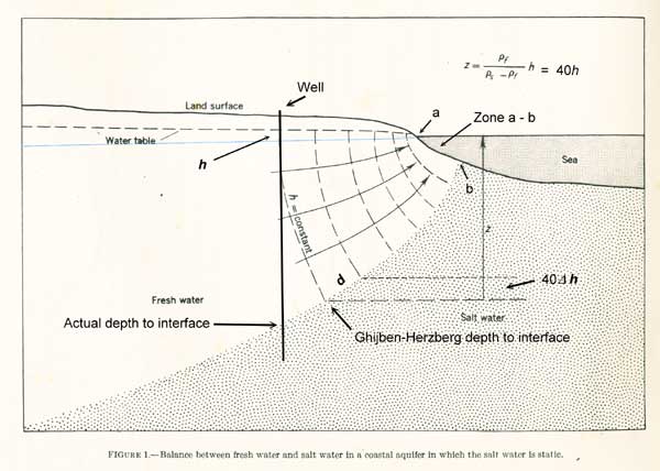
Figure 1. Basic Condition of Sea Water Intrusion.
This figure, adapted from Cooper (1964, p. C2), shows the difference between the true depth to the fresh water-salt-water interface as a function of h, the elevation of the water table above sea level indicated by the added blue line.
RATE OF LOSS TO THE OCEAN
A further aspect of this sea-water intrusion mechanism is the rate at which the fresh water is forced through the surface into the ocean. In theory, this occurs from sea level along the bottom some distance from the shoreline. This distance in the figure is that between a and b in Figure 1. The fresh-water loss to the ocean is that which occurs between a and b per unit length of shoreline. For such loss, De Wiest (1965, p. 299) gives this expression:
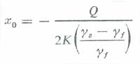
where x0 is the distance between a and b in the figure, γ-values are densities the sea water and the fresh water, K is hydraulic conductivity of the beach sands or other coastal material, and Q, having the dimensions of area per unit time, is a form of transmissitivity. The negative sign simply indicates distance x0 is measured seaward of the shoreline, a convention of DeWiest's diagram. From the figure, and using the average densities as before, this becomes:
xo = - Q (0.05K) -1.
In the figure, the distance between a and b, i.e., xo, defines the zone per unit length of shoreline through which fresh water escapes the aquifer to the sea. This relationship presumably holds for any fresh water level h including the distance between the surface of a fresh-water water body adjacent to the shoreline such as a lagoon, and sea level. As h decreases, so does xo. In effect, this reduces the rate of fresh-water flow to the ocean.
It is to be noted that although neither Q nor xo can be directly measured, it is reasonable to expect that the configuration of the interface is proportional to the gradient of the free surface in the beach sands or other shoreline materials and that it approaches an angle normal to the sea bottom through which the fresh water flows into the ocean. Furthermore, the closer h comes to sea level, the closer the Ghijben-Herzberg approximation comes to the true depth to the interface, and the closer the curvilinear equipotential surface approaches linearity. The geometry of this configuration then should permit a close approximation of xo, which is analogous to the transmissitivity. Given then several measurements of h approaching the shoreline, and a value for the hydraulic conductivity, which generally is isotropic and homogeneous for beach sands, it should be possible to develop a workable empirical estimate of total fresh-water loss along a given stretch of shoreline.
RELEVANCE FOR MALIBU
Sea-water intrusion occurs everywhere along the Malibu coast where the terrestrial materials are sufficiently permeable. The extent to which the interface extends inland from the shoreline is a function of the fresh ground-water head. It is most extensive in the more permeable alluviums at the mouths of streams and particularly that of Malibu Creek. From the foregoing, it should be clear that fresh-water head in the alluvium limits the area through which the ground-water leaks to the ocean. A relatively high head close to the shoreline implies a relatively high rate at which such leakage to the ocean occurs, and vice versa. When coastal water wells are pumped so as to lower the fresh-water head to near sea level, intrusion occurs which can degrade the production to such an extent as to render the well useless as a source of fresh water. In fact, if there were no fresh-water head in a coastal alluvial masses, it would be entirely saturated to sea level with sea water.
Malibu Creek Pollution
The major environmental problem Malibu faces today is the potential for pollution of Malibu Creek and the ocean waters off Malibu Point. Most of the time, creek waters are impounded behind a barrier bar across the creek mouth. In the early days, this condition would have meant a ready source of fresh water for the Rindge farming operations much of the time. Apparently however, it was seen to be more advantageous to have gravity flow from farther upstream. An examination of the record may show that the Rindge water wells in the Malibu Creek floodplain were pumped to such an extent that sea-water intrusion occurred. That probably was the reason the Rindge dam was constructed when a water supply was needed to serve the domestic demands of residential properties beginning to be sold in the 1920s by the Marblehead Land Company.
Periodically, due to some combination of high tide, wave action, and impoundment level, the barrier bar is breached. Then, much of the impounded water drains directly to the ocean carrying with it whatever pathogens and other harmful substances it may contain. Also however, during impoundment, there is a constant flow of ground water through the bar to the ocean in response to the impounded hydraulic head above sea level. Because saturated flow is involved, at least some pathogens probably survive this passage. Furthermore, there is no doubt that possibly harmful inorganic materials dissolved or dispersed in the creek water also pass through the bar. Either type of constituent may be the cause of earlier anecdotally reported illnesses of surfers that now are beginning to be documented. On the other hand, studies in progress so far indicate that the presence of fecal coliforms, and hence the pathogens they imply, is not nearly so great as many have assumed. But in any case, some means of quantifying the manner in which the sea-water intrusion mechanism functions locally is needed if creek pollution of the adjacent ocean waters is ever to be fully understood.
Current Ground-water Study
The Los Angeles Regional Water Quality Control Board recently has threatened to enforce a moratorium on any additional septic systems in the Malibu Creek floodplain and a surrounding area until a centralized sewer system is constructed. Spurred on by this, the City is sponsoring various studies in the hope of offering an "alternative" approach to this "centralized" one. By this is meant a series of studies it is hoped will show that some sort of incremental approach - some modification of septic systems, a smaller treatment plant, or some data demonstrating the risk is not as great as that assumed - so as to avoid the Board's edict.
One of these is that now being conducted by Stone Environmental, Inc. which in 2004 produced an Environmental Risk study of the local area that addressed top some extent the pollution problem. It included application of ModFlow, a well known and widely used computer model that predicts ground-water movement. Unfortunately, in setting up the hydrologic equilibrium equation to apply ModFlow, it was assumed, erroneously, that Malibu Creek is an influent stream, and it was assigned - on what basis it is difficult to imagine - a recharge value of 0.89 cubic feet per second (cfs). As a consequence, hydrologic balancing required a loss to the ocean of 0.60 cfs and a loss to the stream "lagoon" of 1.18 cfs. Certainly one, and probably both must be excessive because Malibu Creek is an effluent stream. Except under extremely rare conditions during peak flood levels, Malibu Creek receives ground water from the floodplain alluvium. It follows that the extent to which the 2004 Stone Environmental Risk study relies on its hydrologic equilibrium data it is erroneous. Nevertheless, at a hearing before the Board on November 20, 2009, a Stone Environmental representative indicated that the Modflow results from the 2004 study will continue to be used.
The correct approach requires an estimate of outflow to the ocean based on observations related to the sea-water intrusion mechanism. Otherwise, any postulated movement of Malibu Creek floodplain ground water using the hydrologic equilibrium equation will be incorrect and almost certainly disastrously misleading.
* * *
|
|
|
|