| |
|
ENVIRONMENTAL LESSONS
of the
MALIBU LAGOON PROJECT
PART III - LAGOON PROJECT HYDROGEOLOGIC CONTEXT
E.D. Michael
July 2, 2014
|
|
The Malibu Creek floodplain has
been significantly modified by changes in its hydrogeologic character. The lagoon project, a small part of that floodplain, is the latest such
modification. Understanding that project requires investigating both its
environmental origins, e.g., as presented in Part II of this review, as
well as its physical character, and particularly its relation to the sand bar
along the shore that periodically impounds
the creek. During impoundment, the creek mouth takes on the appearance of a coastal
lagoon. However, it is questionable whether the creek mouth ever had the
character of a true coastal lagoon, i.e., a coastal fresh-water body that
receives tidal circulation more or less on a daily basis and as a result
develops a habitat especially attuned to a well-circulated brackish condition. Rather, for thousands of years the condition of the Malibu Creek mouth has been
one of lengthy periods of total impoundment followed by drainage when the bar
is breached. When that occurs, the creek mouth is exposed at least as far
upstream as the highway bridge and takes on the character of a mudflat in which
low ridges of coarse-grained flood deposits mostly in the range of coarser
gravels and smaller cobbles are exposed. Nevertheless, with regard to this
condition, such terms as "lagoon" and "estuary" are misleadingly
applied. In fact, there seems to be no specific term for the hydrogeomorphic
condition in the vicinity of the Malibu Creek mouth. Only for convenience,
and with reluctant deference to incorrect local usage, is the periodically
impounded area referred to herein as a lagoon.
EARLY HISTORIC FLOODPLAIN CONDITIONS
The earliest historic document so
far obtained concerning the Malibu Creek floodplain is an undated United States
Surveyor General map drawn for the August 29, 1872 confirmation of Matthew
Keller's title to the Topanga-Malibu Sequit. That map, unsuitable for
reproduction here, shows a stream reach, designated "Arroyo Malibu," upstream
of "Cañada Malibu,"
and a narrow, longitudinal water body designated "Lake" close to, and
parallel with, the shoreline. As that map indicates, the mouth of Malibu Creek
was then situated at the easternmost side of the shoreline just as today. "Lake" probably refers to an inundated condition at the mouth of the creek. However, this
probably was only a generalized cartographic notation. More accurately, the
condition of the floodplain shore area when Frederick Hastings Rindge obtained
title to the Topanga-Malibu Sequit in 1892, reportedly from Keller's son, is shown
by the map reproduced by Doyle, et al. (2012, pp. 61, 68). Part of that
map is shown in Figure 1. |
|
|
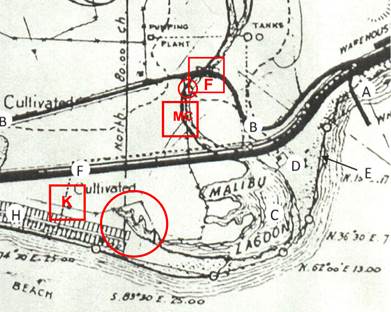
Figure 1. Early Malibu Lagoon Map with Cultural
Additions.
This figure, modified from Doyle, et al. (2012,
p. 61), shows three channel-like lagoonal "arms" as they appeared sometime
prior to 1916. Most, if not all, the indicated cultural features probably were
added about 1931. The southernmost lagoonal arm extended from the creek mouth
to near what later became the eastern side of the initial Malibu Colony subdivision. A indicates the Malibu pier and C the impounded lagoon. At B,
the dashed line represents a track later improved as Serra Road, and D
is next to the Adamson house site on Vaquero Point. Additions in red added for
present purposes include F, the site of a bridge for the original County
Road, close to what is now the intersection of Cross Creek Road and Civic
Center Way, and just upstream of the encircled original ford across Malibu
Creek, MC in the vicinity of what is now the Malibu Country Mart, and K
at the present location of the gate kiosk on Malibu Colony Road. Encircled arm
areas are discussed in the text. Line segments along the shore connecting
encircled points presumably are meant to approximate the mean high tide line. North
to top of page; no scale.
It seems likely that during the
Keller possession, Malibu Creek was crossed by a wagon ford about 2,500 feet
north of the shoreline at a point about 500 feet south-southeast of what is now
the intersection of Civic Center Way and Cross Creek Road. At that time, the road led from location B
in Figure 1 first north-westerly and then curved westerly to the ford encircled
in the figure. Then, the creek mouth - indicated as "Malibu Lagoon"
- extended from its present eastern edge at the base of Vaquero Point to its western
edge incised by three west-trending lagoonal arms separated by low ridges
believed to be remnant shoreline bars.
More important for present
purposes, the effect of that grading was to relocate the western edge of the creek
between the shore and a point roughly 0.6 miles upstream. This eliminated the
pronounced curvilinear creek alignment shown in Figure 1 that had passed
through the area now occupied by Malibu Country Mart and probably included filling
the northernmost two western lagoon arms shown in the figure. It also provided
a site for the western side of the trestle crossing the creek for the Rindge's never-to-be
completed Hueneme, Malibu & Southern Railway. That location was close to where
the west abutment of the present highway bridge now is located.
Thus removed from the normal
stream regimen in the late 1890s or early 1900s, the area directly south of the
western railway trestle abutment as well as others adjacent to the west crossed
later by Pacific Coast Highway and Malibu Road, and north of what now is the
Malibu Colony was used as late as the 1920s for limited agricultural development. However, the part of that land that was to become the lagoon project area thereafter
became a disposal site related to grading for the initial State highway development
in the mid- to late-1920s. As a result, and the remaining lagoonal arm shown in Figure 2 was filled. Probably in the late 1940s, there may have been additional
disposal related to grading for Pacific Coast Highway, and for a time in the
1950s partly for two Little League baseball fields and a parking lot.
|
|
|
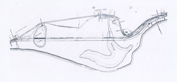
Figure 2. County Road Alignment Section, 1916.
This figure is taken from the work of Rockhold (1916,
Sheets A2 and A6) who surveyed a court-mandated County road through Malibu
Rancho. At the time, the creek was crossed by a railroad trestle where the
highway bridge now is located. The County road alignment crossed the creek
near the original creek ford as shown in Figure 1. Regarding "Malibu Lake," see Part I - Floodplain Development.
| |
Comment
Although the map of which Figure
1 is a part is dated 1931, the physiographic character of the stream channel
and the lagoon it depicts indicate that its base was drawn much earlier. The date
of the base map from which Figure 1 is taken is undetermined, but certainly it
was drawn prior to 1916 - the date of the map shown in Figure 2. Most of the
cultural features shown in Figure 1 such as the Colony subdivision (H), the
Adamson house (D), the pumping plant and tanks, were all added later. The
somewhat tedious account of early grading has been considered necessary to help
counter the impression of a widespread lagoonal condition in the past 2,000
years as postulated in the UCLA study. Until grading for Rindge ranch
operations began, the area immediately north of the lagoon project site was
part of the high-energy Malibu Creek floodplain.
A pronounced easterly littoral
drift
- that for thousands of years has helped to define the geomorphic character of
the Malibu coast - affected both the earlier and later floodplain Malibu Creek stream
regimes discussed in Part I of this review. Periodically, it causes the mouths
of streams at the shore to be closed by barrier bars. Certainly, in latest
pre-historic time, the stream regimen at the mouth of Malibu Creek functioned the
same as today, i.e., with alternating periods of total impoundment and open
flow to the sea.
The indentations encircled in
Figure 1 in the northern side of the southernmost lagoonal arm are remnants of
distributary deltaic floodplain stream channels resulting from late Holocene
lateral stream planation. The linear ridges along the seaward sides of the two
northern arms in Figure 1 are remnants of earlier bars formed as deltaic
deposition that has progressed seaward during latest prehistoric time. The behavior of the bar at the mouth of Malibu Creek has been modified since
the 1920s by bulkheads installed to protect Malibu Colony residences. The
specific manner in which those structures now affect the barrier bar as to its
formation and its semi-static condition is uncertain.
As mentioned earlier, the area
that was to become the site of the lagoon project was completely filled by 1929. Reportedly, it was used as a waste disposal site presumably related to grading
operations for the original Pacific Coast Highway
- also referred to as the "Coast Highway," "Roosevelt Highway,"
and "State Highway" - probably constructed through Malibu Rancho during
the period 1925 - 1929. In any event, from 1929 onward, the eastern edge of
the future lagoon project site remained roughly along a line drawn from the
western highway bridge abutment southward to the western side of the barrier
bar or, when it was absent, the shoreline at the eastern side of the Malibu Colony.
For the more historically
interested, the road alignment shown in Figure 2, officially "Malibu Road"
but commonly referred to simply as the "County road," is part of the
condemnation awarded the County of Los Angeles by the Superior Court
in 1916. Most of the County road was never constructed. A few unpaved graded
sections remain, but it appears there was never any serious intent to construct
the original alignment. Rather, during a poorly recorded period in the mid-
to late-1920s, the first state highway was constructed through Malibu crossing Malibu Creek along the abandoned alignment of the Rindge railway
trestle. However, the section of the County road that crossed Malibu Creek at F
in Figure 1 by way of what appears to have been a low two-lane bridge just
upstream from the original wagon ford was still in existence in 1929. Probably,
was no longer used except possibly for ranch operations. Subsequently,
it was either physically removed or perhaps destroyed during a flood. However,
the County road section across much of the floodplain west of that bridge remained
in use and was renamed "Civic Center Way," probably in the 1940s.
ECO-CHANNEL DEVELOPMENT AND DECLINE
For many years after the filling
completed during or prior to 1929, the area that was to become the lagoon project
laid fallow. In 1983, it was bounded on the north by the highway, on the west
by a recently constructed private pitch-and-putt golf course, on the south by an
easternmost section of the Malibu Colony, and on the east by the artificially
induced western creek mouth shore. About that time, according to the report by
Ambrose and Orme (op. cit., p. 9-9), also referred to as the UCLA study,
the DPR:
"... initiated a salt marsh restoration project
..." in the 16-acre project site "... to reintroduce tidal flow to
the area..." by construction of "tidal channels" in what later
would be the project area..."
Reportedly, those channels were
to be one to two meters deep. Since their purpose was to introduce ecological
conditions unrelated to drainage or stream flow, it is appropriate to refer to
them as "eco-channels."
Based on the
only data immediately available,
elevations in the project area at the time ranged from about 2 - 8 feet,
presumably mean sea level (msl), with average elevations of about 5 feet msl
and an arithmetic mean of about that value. Consequently, eco-channel invert
elevations probably would have ranged from about +2 to -1 feet, msl. Three
channels were constructed "... (U)nder the direction of a group of
biologists and landscape architects ... and seeded with salt marsh plants in
1983" (op. cit., p. 8-3). They had a total length of about 3,500 -
4,000 feet (see Photo 1, below).
During the following twenty
years, environmental conditions in the eco-channels declined. Sutula, et al.,
(2004), although concerned primarily with sources of nutrients in the lagoon,
offer certain insight regarding the extent to which adverse physical conditions
in the eco-channels had developed by 2002. In particular, they note that the
channels then supported growths of Ruppia maritima, a salt-tolerant fresh-water
plant - commonly called "widgeon grass" - and occasionally "... green
mat-forming mats such as that of the alga Rhizoclonium hookeri... which
in excessive abundance can reduce habitat quality ..." (op. cit.,
pp. vi., 1, 3). It was observed by one of these co-workers, K. Kramer, that the
widgeon grass was so dense in September 2002, that it impeded circulation (op.
cit., p. 18). Since conditions in the absence of the widgeon grass apparently
were not observed during that study, this seems simply speculative insofar as
suggesting at any time there was significant eco-channel circulation.
Comment
The map of which Figure 1 is a
part probably was provided DPR by the grantors,
possibly as early as the time of the 1978 study, and certainly well before the
actual transfer of title in January 1984. A comparison of Figure 1 with Photo
1, below, strongly suggests that axes of the eco-channels were patterned after
the original lagoon arms. It probably was the intention in excavating the
eco-channels to construct a physical habitat similar to that which existed late
in the 1890s as shown in Figure 1 based on the assumption that they were
natural features. Since this intent was faithful to the idea of restoration,
the resulting adverse environmental conditions - especially as noted by Sutula,
et al. ( op. cit.) - must have been seriously dismaying. Algae,
such as R. hookeri, are considered an environmental no-no because they tend
to induce hypoxia. Also, they demonstrate the presence of nutrients and commonly
are thought to imply - not always correctly - pollution. Besides, they look
icky. Flow from the impounded creek mouth into the eco-channels of course resulted in
a certain kind of ecological development in response to the induced artificial
conditions. But the concept of restoration so extensively relied by the
eco-channelers and all the lagoon project proponents since is clearly baseless
because: [i] there is specific record of the natural biota at the time the
Rindges took title, and [ii] the dredged channels in no way could replicate the
actual hydrodynamic conditions under which the natural lagoon arms of Figure 1 had
been formed. Attempting to "restore" an artificially modified coastal
site such as the mouth of Malibu Creek without understanding either its
original or existing hydrodynamic character seems rather like applying sun-tan lotion
to cure leprosy.
HYDRODYNAMIC OBSERVATIONS
To reiterate, as discussed in
Part II of this review, the formulating studies for the lagoon project were
those of Dagit (1989) and Dillingham and Sloan (1989), both of the 1989 survey,
and parts of the UCLA study. Those, together with the feasibility and implementation
reports by Moffatt & Nichol (M&N) staff (2005 a,b), were the works upon
which the lagoon project came to be formulated. By way of specific analysis, Dillingham
and Sloan (op. cit.) noted with reference to the eco-channels (op.
cit., p. 63):
"In 1983, approximately 36 acres (sic) of
the lagoon were restored. This included most of the study area where channels
were dredged with U-shaped cross section and steep sloping banks. In the five
year period since restoration the Lagoon has changed only slightly in
morphologic features, with partial to complete infilling of the channels."
Further, and more important for
present purposes, they took note of conditions during outflow from the
eco-channels (see Fig. 4, below) as follows (ibid.):
"Observations made during a 24 hour survey in
June 1988 indicate that when the entrance to the Lagoon is opened by the
bulldozer, water flows faster out of Channel C than from Channel B. Flow out
of both channels have [sic] been clocked at a 1 inch drop in water level
in slightly less than 2 minutes. It is only when levels in the Lagoon drop below
2.75 ft. that circulation patterns in the inlet channels change. At that point
the sand bar at the mouth of Channel C is exposed, and water from all the
inlets must flow out of Channel B."
Artificially breaching the
barrier bar, as previously noted, had been "mandated" by DPR based on
the 1978 report. At the time, concern had developed regarding whether treated
Tapia reclamation plant effluent disposed in Malibu Creek represented a health
hazard
per se, or somehow was rendered so by lengthy impoundment. This, like a
similar issue regarding septic-system effluent in the creek from floodplain
developments, remains to be clarified. In any event, it was determined to
shorten the period of impoundment presumably to reduce possible bacterial or
other harmful organism gestation. As noted by Dillingham and Sloan (op. cit.,
p. 69), in order to limit the impounded water level to an elevation no higher
than a "... mandated 3.5 ft ...,"
the plan was to have a bulldozer cut a channel in the bar. The informality of
this procedure is indicated by the "... difficulty of getting the one
bulldozer to the Lagoon to open the entrance..." when the level reached
that elevation so that on occasion the level would reach as high as 5.2 feet (ibid.).
Conditions noted by Dillingham
and Sloan (op. cit.) concerning bar breaching are illustrated in Figure
4. In this regard, they state (ibid.):
"Water circulation patterns in the Lagoon remain
to be studied if the sediment patterns are to be fully understood. For
instance, the building of a sand bar at the entrance of C channel has
significantly altered water flow patterns in the B and C inlets, directing all
flow through channel B when water levels are below 2.75 feet. The result is
that water often stagnates at Station D .... Management of an ocean entrance to
maintain water quality in the Lagoon throughout the year has surely increased
the rate of deposition of both sand and organic material (drift algae) near
this managed entrance. "
|
|
|
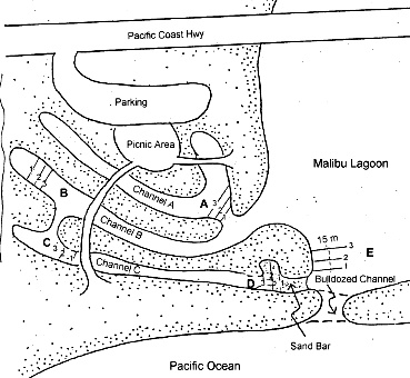
Figure 4. 1989 Study Sketch Map 4A.
This
figure, from Dillingham and Sloan (op. cit., Ch. 4, p. 64) is relabeled to
show north to the top of the page; no scale.
| |
It is especially relevant to note
the sand bar that developed just downstream of location D at the outlet of
Channel C. Such a deposit is due to aggradation. Although the sketch shows aggradation at the outlet of Channel C, similar
deposits occur at the inlet of the channel breaching the bar as drainage reduces
the gradient in the inundated area, and at the outlet when tides raise the ocean
base level.
The part of the UCLA study most
relevant in this regard is that by Orme, et al. (2000, Ch. 2, pp. 2-1 -
2-112), and particularly Section 2.5.1 titled, "Tidal Channel Hydrodynamics"
(ibid., pp. 2-71 - 2-97). During the period of late September 1997 to
late October 1998, their observations were concerned primarily with breached
channel flow rates and changes in lagoon water volumes. Their description of
the thalweg of a bar channel soon after its breaching at an elevation of -1.7
meters rising in a few weeks to 0.0 meters,
and also their observation that the "...0.0 elevation, routinely observed
throughout the water year, appears to represent a quasi-equilibrium for the
throat of the tidal channel ..." (op. cit., p. 2-77) are especially
germane to the issue of breaching channel behavior in relation to that of
nearby lagoon tributaries such as the eco-channels. It is instructive to
compare Figure 4 with Photo 1. Although aggradation at the outlet of channel C
shows no aggradation there, it is occurring just downstream of the breaching channel inlet.
|
 |
|
Photo 1. 1983 Eco-channels, ca. 2005.
This photo is presented rather than Figure 1.4 from
the study by Dillingham and Sloan (op. cit.) showing the eco-channels
which is unsuitable for reproduction. Lighter hues in the breaching channel as
well as along the landward shore of the bar compared to those upstream both in the
lagoon and the eco-channels are a result of aggradation. Photo: M&N staff (2005b,
p. 2, Fig. 1).
| |
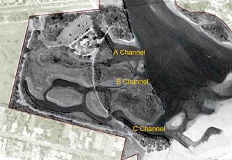
The initial study by M&N
staff (2005a) was concerned with both the lagoon, referred to as the "main
channel," and area of the eco-channels referred to as the "west
arms" (op. cit., Sec. 3.2, p. 18). Its focus was an analysis of physical
characteristics - primarily those of the west arms - in order to determine
means of increasing tidal flushing, circulation, and holding capacity (op.
cit., p. 6). M&N's approach to the problem of maintaining
"restored" lagoonal conditions despite periodic creek flooding involved
a berm as an integral part of Alternative #1.5 described as follows (op. cit.
p, 44):
This alternative proposes to install a
naturalized berm along the western side of the main lagoon from the PCH bridge
to the new channel opening on the south. The proposed naturalized berm will be
at an elevation of approximately +2 feet msl (or 1 feet above the existing
cobble berm or "speed bump") to physically separate the western arms from the
path of the bed sediment load in the creek during storms, yet low enough to be
inundated during closed conditions to provide for wind fetch. The naturalized
berm will be constructed in a manner similar to that of the existing "speed
bump," utilizing stone materials found within the lagoon. The design of the
naturalized berm needs to be confirmed with additional analysis at a later
stage to specify the appropriate effective crest elevation. The elevation may
range from the +2 feet shown here by 1 to 2 feet vertically. The significance
of constructing the berm to the appropriate elevation is that a berm that is
too low may result in damage to the newly-restored marsh from sedimentation during
certain flood events that may render the restoration ineffective or even reverse
restoration benefits. A berm that is too high may impede the circulation of surface
waters during closed conditions reducing benefits of water turnover and
oxygenation.
Except to note differences during
lagoon open and closed conditions, no attention was given to the manner in which
a bar-breaching channel behaves. However, the study does provide the only
useful data in the entire record thus far reviewed regarding elevations of the barrier
bar which at the time were 5.8 feet at the west end, 6.7 feet near the center,
and 8.2 feet at the east end (op. cit., Fig. 16, p. 24). Presumably, these
data refer to the National Geodetic Vertical Datum of 1929 (NGVD1988).
Aside from the questionable
efficacy of the proposed "speed bump" barrier, the results of a
numerical model employed by M&N staff (2005a, App. 3) are of special
interest. That model, based on a version of the well known Hjulstrom-Sunborg
curve, was used to produce theoretical distributions of deposits under a
variety of conditions including both deposition and flushing
"potentials" for existing average and 5-year maximums for both
Alternatives #1.5 and #1.75. Essentially, the model predicts grain-size
materials to be deposited or left undisturbed under both ebb-tide and
flood-tide conditions. All the modeled conditions resulted in either pebbles
or very coarse sand deposited at the outlet of the Alternative #1.5 C channel which
is essentially a modification of channel C in Photo 1. Reproduced Figures 6a
and 6b show the results most relevant for present purposes. Apparently, the
model assumes the DPR's "mandated" procedure of artificially breaching
the channel at the southernmost edge of the inundated lagoonal area according
to a planned resource objective announced by Tjaden, et al., (1978, p.
10, § 6).
|
| 
| |
6a.
|
6b.
|
| |
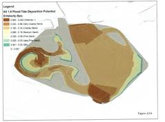
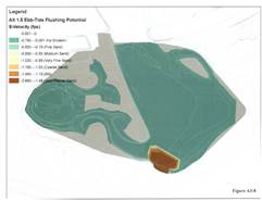
Figure 6. Alternative #1.5 Deposition and Flushing Potentials
These results of the numerical model applied by M&N
staff (2005a, App. 3) demonstrate the tendency for deposits to develop at the
mouth of Channel C close to the inlet of the breaching channel at the
southernmost point of the inundated area. The ebb-tide depositional regime of
Fig. 6b predicts deposits there of grain sizes of silt to coarse sand.
| |
M&N conclusions significant
for present purposes are those assuming the open condition as discussed by M&N
staff (2005a, Sec. 5.1.2, p. 61). There, it is clear that their hydrodynamic analysis
is limited to flow velocities expected to develop in either the Alternative
#1.5- or #1.75-modified eco-channel systems in response to flood- and
ebb-tides, the former tending to close them and the latter tending to keep them
open.
Comment
Malibu Lagoon represents a
complex hydrodynamic system that is strongly a function of seasonal periodicity. The
studies by Dillingham and Sloan (op. cit.), Orme, et al. (op.
cit.) and M&N staff (op. cit.), as well as that by Dagit (op.
cit.) generally indicate the kind of monitoring desirable to determine the
environmental character of both the lagoon area proper and tributaries such as the
eco-channels. However, to be effective in terms of planning for any long-term modification
of the creek mouth, similar such studies must be carried out over a significant
part of a wet-dry cycle which in southern California - as demonstrated by the
work of Troxell and Hoffman (1954) previously mentioned in Part II - have
periodicities in the range of 10 - 50 years. Similar data, together with carefully
monitored effects of Tapia plant effluent stream-disposal over such a period,
would have been a proper scientific basis for considering the feasibility of the
lagoon project or any similar venture.
The preoccupation of planners with
the geometry and storage in the lagoon proper - i.e., the periodically
impounded creek mouth - is difficult to understand, because that cannot be
controlled by any feasible means. Consequently, such data have little if any predictive
value. Whether regarded as a lagoon or a periodically impounded deltaic mudflat,
natural deposits at the mouth of Malibu Creek to the shoreline will always be above
mean sea level. Similarly, bar development at the creek mouth presents a natural
condition that in the absence of artificial modification will persist with a
depositional regime entirely independent of stream flow except for periods when
it is removed due to flooding. Whether or not artificially breached from time
to time, its mechanical response is to reform itself as a total barrier according
to a well defined physical regime. In the absence of artificial channel
breaching, the closed condition period is inversely proportional to the level
of inundation, in turn primarily a function of surface inflow and subsurface
outflow. As an observable consequence, it commonly persists for months during
the dry season when the creek does not receive Tapia plant effluent and
therefore belies any interpretation of the creek mouth as a true tidal lagoon. Nor
can it properly be regarded as a wetland as commonly defined.
The over-all purpose of the UCLA
study was to develop data in support of strategies for managing the long-term
development of the Malibu Creek lower watershed, by which seems to have been
meant the creek floodplain - a rather daunting task - especially in the absence
of local basic data.
Regarding the creek's behavior, attention necessarily focused on the open and
closed conditions. It is regrettable that in observing a breaching channel's
lateral development more attention could not be given to effects induced by its
aggradation, but at the time, lagoon project planning was still in early
formulation stages, and the study period was limited, essentially, to a single
year of observation.
REVISED PLANNNING
Issuance of the M&N reports, followed
by the draft and final environmental impact reports (EIRs) by Jones &
Stokes staff (2006 a,b) determining Alternative #1.75 to be environmentally
superior, and DPR's subsequent decision to undertake Alternative #1.5 as more
feasible, would seem to have ended in 2005 the period of formal lagoon project
planning even though not without question from a hydrologic view point
concerning the "naturalized berm." On this subject, as noted by
Michael (2006), after venting his spleen - a procedure in which he engages, regularly,
this time about what is and is not a lagoon - he states:
"The other invalid premise is that hydrologic
conditions in Malibu Creek permit creation of a sort of laboratory lagoon in a
new channel. Now proposed is a problematical "naturalized berm" allowing
entry of low-flow stream water but not sediment-laden flood water at the
channel head and a permanent opening in the bar opposite the channel mouth,
about 300 feet east of the Colony. Theoretically, the bar would stay open by
flow in a dredged feeder channel from the main lagoon, but at flood cessation,
that channel would fill with debris when the stream velocity reduces. All
streams do that."
In any event, and presumably
sometime thereafter, Jones & Stokes was hired to produce a new design for
the lagoon project entirely different from Alternative #1.5. Hence, the Jones
& Stokes plan by civil engineer Steven R. Seville - begun sometime prior to
October 5, 2007 and completed, presumably sometime in November 2010 - thereafter
became the ICF Int. (ICF) plan submitted in support of the application for a
coastal development permit (CDP). In
was in its near-final stage of design that the ICF plan was submitted to
CCCom and assigned CDP number 4-07-098.
| 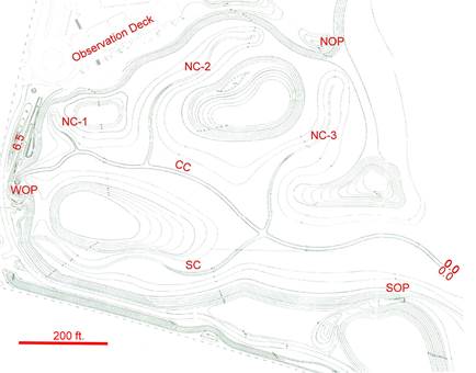 | |
Figure 7. ICF/Jones & Stokes Lagoon Project Topography.
The contours of this figure represent the grading plan
by which the lagoon project was actually constructed. Notations in red have
been added for future reference. EOP, SOP, and WOP are the locations of the
eastern, southern, and western observation points. CC is the system's
first-order channel. NC letters with numbers refer to the three northern second-order
channels. SC is the southern second-order channel. The numeral 6.5 is the
approximate mean sea level elevation of the WOP platform. 0.0 numerals indicate
the elevation of system outlet, presumably at mean sea level, where channel CC
meets the western edge of the lagoon close to the point where, periodically, inlets
of "mandated" bar breaching channels are opened. North to top of
page; scale approximate.
| |
A protracted period of CCCom
review due to local opposition based on biological concerns is not relevant for
present purposes, but it did require two extensive CCCom staff reviews, both of
which recommended issuance of CDP 4-07-098. It seems clear that CCCom staff,
apparently lacking any training in hydrodynamics, simply assumed that the
project would function satisfactorily. Nevertheless, CCCom staff hedged its
bet, as indicated by Tysor (2010a, Sec. 5, B2), by requiring that if monitoring
the project subsequent to construction does not indicate that circulation
"...within the lagoon ..." - and presumably the lagoon project as
well - revised plans will be issued indicating "... additional or supplemental
measures to modify those portions of the original plan .... not in conformance
with the original approve lagoon restoration plan."
Comment
When the matter of CCCom approving
a design different from that which had been considered in the EIRs was
informally questioned, project manager Marc Abramson, who by then had moved
from Heal the Bay to the Santa Monica Bay Restoration Foundation, is reported
to have said that the Jones & Stokes plan was just a "scenario" -
presumably meaning a slight variation - of the carefully studied and vetted
M&N designs. Such a view is, of course, preposterous. More importantly,
the two plans - Alternative #1.5 and that of ICF/Jones & Stokes - both are
predicated on first-order dendritic channels with their outlets close to the
point where, over the years, the mandated drainage channel has periodically
been opened. Therefore, both lagoon project designs seem simply to assume that
adequate circulation and tidal flushing will necessarily occur as
a result of a channel system with its outlet at mean sea level opposite the
inlet of a bar-breaching channel. Neither
considers in detail the manner in which the breaching channel itself performs
- a subject only briefly considered in the 1989 survey and the UCLA study. In the closed condition, it is
noted (M&N staff, 2005 a, Sec. 5.1.1, p. 55) that "... the only
feasible forcing mechanism to move the water in the lagoon during closed conditions
is to increase the circulation effects of the wind ...," and this clearly
is meant to apply to either Alternative #1.5 or #1.75. Further, it is
concluded that the effect of such circulation can only be determined by a
system of careful and detailed observations while recognizing that until
unspecified "... source reduction efforts are implemented ..." reduction
in eutrophic conditions would be limited (Moffatt and Nichol staff, 2005b, Sec.
2.3.2, pp. 20-21). In other words, during the closed condition, circulation
due to wind alone probably would not be sufficient to prevent algae development
and induced hypoxia unless nutrients from either the Tapia plant or local
septic systems are reduced.
Apparently, it was assumed that
such analysis also applied to the ICF design. In the absence of criteria
other than those upon which the M&N designs were based, it seems clear that
the ICF design took into account the fact that - as earlier observed and as the
model predicted - aggradation such as that illustrated in Figures 4, 5, 6a, 6b,
and in Photo 1, was to be expected. To better understand matters, the hydrodynamic
character of the breaching channel should have been carefully considered. However,
insofar as the record reflects, it was not.
So far as the record discloses,
planning has entirely ignored the possible effects of sea-water intrusion in lagoon
project channels. This process, initially referred to as the Ghyben-Herzberg
principle in recognition of its early investigators in the late 1880s, given a
rigorous interpretation by Hubbert (1940, pp. 924-926), and extensively quantified
by Cooper, et al. (1964), need not be elaborated here. It suffices for
present purposes to note that because of the relatively higher density of
saline water, its occurrence inland in an adjacent terrestrial mass saturated
with fresh ground water is a function of the fresh-water head above sea level
and the local hydraulic conductivity which affects the rate of diffusion, and
hence the thickness, of a saline-intruded zone and its proximity to the surface
landward of the shoreline. In practical terms, this raises, first, the extent
to which saline-diffused water may enter project channels, second, whether in such
a diffusion process, algae also are introduced, and third, if so, the extent of
any related algae bloom.
BARRIER-BAR
HYDRODYNAMIC REGIME
The fully formed bar that much of
the time prevents open flow of Malibu Creek to the ocean is the product of a dynamic
system that forms by longshore littoral drift causing beach sand deposition in
the lee of Malibu Point. The salient of that point lies directly offshore from
the eastern end of the Malibu Colony due to a localized resistant reef outcrop,
probably basalt or andesite intrusives of the Zuma Volcanics of Yerkes and
Campbell (1980). There, the bar sands overlie deltaic stream deposits of gravels,
cobbles, and small boulders, and they probably never exceed about five feet in
thickness. Orme, et al. (op. cit., Sec. 2.51, pp. 2-49 - 2-78)
present a useful introduction to the manner in which a barrier bar behaves when
breached.
Once breaching outflow begins,
the loose bar sands are easily entrained so that a relatively deep channel
immediately develops. If at the beginning of a breach the impoundment level is
very high and there is a low enough tide level, the breaching channel probably
is eroded deeply enough to expose underlying deltaic deposits of gravels and
cobbles and in the bottom of the impounded area exposed trains of gravels and
cobbles - low ridges of the most recently released flood-stream load deposits -
separated by intervening sand- and silt-filled scours giving the entire area much
the character of a mudflat. During the normal breaching process, the drainage
velocity is so low that only finer-grained materials from the inundated area are
incorporated in the flow. Consequently, much of the mudflat material, silts
and finer-grained sands are left exposed in the drained area. Only in the
breach itself is the drainage velocity great enough to entrain the bar sands.
Although not so far described in
the record, it is obvious from direct observations that the barrier sand bar at
the mouth of Malibu Creek functions according to - for want of a better term - a
"master" hydrodynamic regime which, arbitrarily, consists of a single
bar-forming mechanism and three well defined, and interdependent cyclical bar-breaching
channel sub-regimes. The bar-forming mechanism operates at all times
essentially by a combination of surf and tidal conditions that causes beach
sand to be deposited above the littoral zone, and it is independent of both
the breaching channel mechanism as well as creek flow except during flooding so
great as to entirely erode away the bar.
Beginning when the bar has been
completely formed, the following sub-regimes of the bar-breaching channel
mechanism can be regarded as developing sequentially:
Sub-regime [i] - Beginning with total impoundment: rates
of impounded volume increase and surface elevation rise are functions of precipitation,
surface runoff, Tapia-plant effluent inflow, and bank-storage inflow, the total
of which is reduced by rates of evaporation, transpiration, and ground-water outflow
through the bar.
Sub-regime [ii] - Barrier-bar breaching: after
sufficient rise in the impoundment, and probably on occasion in combination
with higher tides and surf, a breaching channel forms generally transverse to
the bar length and normal to the shoreline, initially with a high flow rate and
velocity that gradually decreases as the impounded surface elevation decreases.
Sub-regime [iii] - Barrier-bar redevelopment: easterly
longshore current entrainment and deposition of bar and beach sands at the
channel outlet causing it to shift laterally eastward thus lengthening the
channel, and causing it to develop the classic concave-bank and associated
convex-bar manner of low-energy streams so as to transform the initial deep,
southerly draining channel stream to one aggraded and draining
east-southeasterly diagonally through the bar with a broadly meandering course
until its outlet reaches the easternmost side of creek mouth where reduced
channel flow enables littoral drift deposits to close the outlet thus reinitiating
total impoundment.
Certain aspects of this master
regime have been reported by Dillingham and Sloan (op. cit.), Schwarz
(1999), and Orme, et al. (2000), but none with regard to its effects in
the impounded area. Apparently the previously announced objective of the 1978
study of periodically artificially breaching the bar had been accomplished to
some extent up to the time of the work of Dillingham and Sloan (op. cit.),
and presumably thereafter perhaps as late as 1998-1999, the period of the UCLA
study.
In one way or another, mandated
bar breaching has been accomplished at least since 1989. In recent years, this
has involved - to use one County lifeguard's term - cutting a "notch"
in the inner edge of the bar at the southernmost edge of the lagoon. Presumably,
when the impounded level rises high enough, it first flows into the notch so
that is the place where overflow and hence breaching occurs. Ostensibly, the
purpose of this is to keep the drainage as far as possible from the more
populated surfing area. However, this also considerably lengthens the period
during which there can be lagoon-like tidal entry.
Comment
During the current drought, the
flow rate has been almost entirely due to Tapia plant effluent discharge to
Malibu Creek which is permitted only from November 15 through April 15. Consequently,
the period of total impoundment can be quite lengthy. For example, during
2002, 2003, and 2004, impoundment persisted for periods of seven months, five
months, and at least three and one-half months, respectively, as noted by M&N
staff (2005a, p. 9, Table 2) in citing the work of Sutula, et al.
(2004).
Deposits in the mudflat of the
lagoon or "main channel" as described by M&N staff are a result
of aggradation as the stream load is deposited on reaching ocean base level and
also locally that of the inundated area. The sand bar shown in Figure 4 at the
mouth of Channel C is the earliest recorded example of an aggraded deposit specifically
associated with a bar-breaching episode. To explain the "sand bar"
of Figure 4, it is to be inferred that it formed as a result of stream load
deposition upon reaching the local base level at the outlet of Channel C
adjacent to the inlet of an artificially induced breaching channel.
During field work for the UCLA
study, Orme, et al. (op. cit., Sec. 2.5.1, pp. 2-75 - 2-76)
observed an irregular increase in the elevation of a breaching channel thalweg
of approximately one meter (3.281 feet) during the period of late April to July
29, 1998. Since their attention was limited to the specific behavior of the
bar at the time, little attention was given to breaching channel hydraulics. However,
their observations have a certain serendipitous value in that they describe
barrier-bar behavior during a wet period which is to be compared with that now prevailing
in response to the continuing drought. At the time of the UCLA study,
breaching channels behaved in response to streamflow that included increments
of surface runoff, relatively high bank-storage effluent,
and Tapia-plant effluent, whereas today because of drought conditions streamflow
is almost entirely due to Tapia-plant effluent with a somewhat lesser increment
of bank storage. The result is simply a focus on two distinct patterns of
barrier-bar behavior, the importance of which is the longer period of
impoundment and hence lack of circulation when drought conditions prevail.
For present purposes, tidal data
at Santa Monica, California may be taken as that representative of elevations
used by M&N staff (2005a). According to Reid, et al. (2012,
App. C, p. 5) the current tidal datums (sic) in feet for Santa Monica are:
Highest observed water level (11/30/1982) = 8.63
Mean higher high water MHHW = 5.49
Mean high water MHW = 4.73
Mean tide level MTL = 2.84
Mean low water MLW = 0.95
Mean lower low water MLLW = 0.00
Lowest observed water level (12/17/1933) = -2.70.
These are close to the
"MLLW" data used by Orme, et al. (op. cit., Table 2-6,
p. 2-57) converted from meters to feet. Consequently, their observations have
relevance for certain observations during the open condition in relation to
project water levels with respect to observations at the WOP of Figure 7 where
the level of the deck is approximately 6.5 feet msl, based on inscribed
decorative tiles installed along the walkway leading to the WOP.
Aggradation of the breaching
channel at its inlet as well as along its axis is extremely important in considering
the character of circulation and drainage from both the lagoon and the project
area as well as the extent to which they can occur during both the open and
closed conditions. The littoral drift mechanism includes the manner in which the
barrier bar forms as well as the process by which the outlet of the breaching
channel is closed. Mechanical analyses of grab sand samples along the entire
stretch of the bar show 90 percent of the gain sizes of six individual samples
between 0.35 and 0.12 millimeters. Curves shown by Pettijohn (1975, Fig. 15-1)
from the work of Hjulstrom (1935, Fig. 18) indicate such materials are
transported either by traction or suspension in streams with velocities of 1-3
centimeters per second (cm/s).
Further, on February 20, 2014,
velocities observed in a well developed meandering breaching channel commonly
ranged from near zero up to about 30 cm/s along the central channel axis for a
period of about an hour during which the volumetric flow rate was seemed
essentially constant at about 6.6 cubic feet per second, equivalent to 4.3 million
gallons per day (mgd). According to Dingman (2014), Tapia effluent disposal on
that day was 3.01 million gallons. Considering probable release only during
part of the day, this suggests a fairly direct relation between plant effluent release
flow and breaching channel flow. Such observations appear to be a reliable
basis upon which to predict the manner in which the lagoon project can be
expected to perform during the open condition. Observations of flow over the
Rindge dam spillway should be similarly instructive.
References
Ambrose, Richard F., and
Anthony R. Orme, 2000, Lower Malibu Creek and lagoon resource enhancement and
management: Univ. Calif. Los Angeles, special study for California Coastal
Conservancy.
Cooper, Hilton H., Jr., Francis A. Kohout, Harold R.
Henry, and Robert E. Glover, 1964, Sea water in coastal aquifers: U.S. Geol.
Survey WSP 1613-C.
Dagit, Rosi, 1989, Ch. 2, Physical and chemical
parameters of Malibu Lagoon in Malibu Lagoon: a baseline ecological
survey, B. Sean Manion and Jean H. Dillingham, eds.: Topanga-Las
Virgenes Resource Conservation District rpt. for Los Angeles County Dept.
Beaches and Harbors and California State Dept. Parks and Recreation under Grant
#4-400-7171, pp. 17-42.
Dillingham, Jean H., and Katherine M. Sloan, 1989, Ch.
4, Sediment Survey in Malibu Lagoon: a baseline ecological survey, B.
Sean Manion and Jean H. Dillingham, eds.: Topanga-Las Virgenes Resource
Conservation District rpt. for Los Angeles County Dept. Beaches and Harbors
and California State Dept. Parks and Recreation under Grant #4-400-7171, pp.
63-72.
Dingman, Brett, 2014, Tapia
plant discharge schedule: e-mail, courtesy David Llippman.
Doyle, Tomas W., and Ronald
L. Rindge, with William R. Clarke and Glen Howell, 2012, Malibu Rails and
Roads: Malibu Adamson House Foundation, 100 pp.
Hjulström, F., 1935,
Studies of the morphological activities of rivers as illustrated by the River
Fyris: Bull. Geol. Inst. Uppsala, v. 25, pp. 221-527.
Hubbert, M.K., 1940, The
theory of ground-water motion: Jour. Geol., vol. 48, no. 8, November-December.
Jones & Stokes staff,
2006a, Malibu Lagoon Restoration and Enhancement Draft EIR: Jones & Stokes
in cooperation with Terry A. Hayes Assoc. rpt. for DPR, RCDSMM and CCCon,
January.
Jones & Stokes staff,
2006b, Malibu Lagoon Restoration and Enhancement Final Environmental Impact
Report (EIR): Jones & Stokes in cooperation with Terry A. Hayes Assoc. rpt.
for DPR, RCDSMM and CCCon, March.
M&N staff, 2005a, Malibu
Lagoon restoration feasibility study final alternatives analysis: M&N in
association with Heal the Bay rpt. for California State Coastal Conservancy
& California State Parks, March.
M&N staff, 2005b, Final
Malibu Lagoon restoration and enhancement plan: M&N in association with
Heal the Bay rpt. for California State Coastal Conservancy & California
State Department for Parks and Recreation, July 17.
Michael,
Don, 2006, Ltr. to Malibu times, March 17.
Orme,
Antony, Kenneth Schwarz, Priya Finnemore, Mark Khulman, and Johannes Feddema,
2000, Ch. 2, Hydrology and Morphodynamics in Lower Malibu Creek and
lagoon resource enhancement and management, Richard F Ambrose and Antony Orme,
principal investigators: Dept. Geography, Univ. Calif. Los Angeles, final
report to Coastal Conservancy, pp. 2-1 - 2-223, May.
Pettijohn,
F.J., 1975, Sedimentary Rocks, 3rd ed.: Harper & Row, Pubs., Inc.
Reid,
Gregory S., Trans Systems staff, and exeltech staff, 2012, Dan Blocker Beach parking lot wave run-up and coastal analysis report rpt. for Mr. Ed Andrews,
L.A. Co. Dept. Public Works, September 10.
Rockhold, J.E., 1916, Map
showing land to be condemned for the opening of the new "Malibu Road, Pacific Coast Hy." through Rancho Topanga Malibu Sequit: County Surveyor, Sheets A2 and A3, March - July.
Schwarz, Kenneth Michael,
1999, Hydrogeomorphology of Malibu estuarine lagoon: Univ. Calif. Los Angeles,
Dept. Geography PhD dissertation (Call no. LD 791.9 G2 S411).
Sutula, Martha, Krista
Kramer, and Jaye Cable, 2004, Sediments as a non-point source of nutrients to
Malibu Lagoon, California: Southern California Coastal Water Research Project
Tech. Rpt. #441, Final report to LARWQB, November 1.
Tjaden, Albert, Jean Roberts,
and Ken Pierce, 1978, Malibu State Beach, resources management plan, general
plan, and environmental impact report: California Res. Agency, Dept. Parks and Recreation spec. rpt., April.
Troxell, Harold C., and
Walter Hoffman, 1954, Hydrology of the Los Angeles region, Ch. VI, Cont. No. 1, Geology of Southern California: Calif. Div. Mines Bull. 170.
Tysor, A., 2010a, California Coastal Commission Staff Report Regular Calendar, Item Th19a re Application
4-07-098, July 29.
Yerkes, R.F., and R.H.
Campbell, 1980, Geologic map of the east-central Santa Monica Mountains, Los
Angles, County, California; U.S. Geol. Survey Misc. Inv. Series Map I-1146.
* * *
End Part III
County
lifeguards indicate that breaching
currently is induced by mechanically "notching" the interior edge of
the bar at its southernmost point so that when the inundation level rises high
enough for overflow, or erosion during high surf coupled with high tide occurs,
a breaching channel develops at that point. However, it is conceivable that
during lower tides and especially high impoundment levels, headward erosion of
an open spring-flow channel in the seaward face of the bar, or a tunnel-like
channel which under some conditions forms in a process called
"piping," can reach the impoundment to cause breaching.
|
| |