| |
|
ENVIRONMENTAL LESSONS
of the
MALIBU LAGOON PROJECT
PART IV - LAGOON PROJECT HYDROLOGIC CONSIDERATIONS
E.D. Michael
October 25, 2014
|
INTRODUCTION
Construction of the Malibu lagoon project began about June 1, 2012. The project's ribbon-cutting ceremony on
May 3, 2013 may be taken as the official date of project completion, although
the parking area, i.e., Phase I of the project, remains unpaved. Phase
II, including grading, construction of walkways and other peripheral elements,
and landscaping, all were close to completion by early March, 2013. A certain
amount of grounds-keeping and irrigation in support of the "natural"
vegetation continues; otherwise, the lagoon project now appears complete. However, although the design of project in terms of recreational use appears
adequate, the record to date shows that insofar as its hydrologic purpose is
concerned, it fails to function properly. As a basis for this assertion, it first
is desirable to describe the method of hydrologic equilibrium.
HYDROLOGIC EQUILIBRIUM
The science of hydrology concerns
the physical relationships of water to the earth. An important approach to
such study is the method of hydrologic equilibrium which considers the manner
in which water occurs within a volume - essentially a vertical column - that
includes both the atmosphere to some arbitrary elevation and the subsurface to
some arbitrary depth. Generally, the horizontal cross-section of such a column
conforms to an area of the earth's surface that is of economic interest, and it
is applied for a given period during which gains and losses of water to and
from the volume are balanced much like book-keeping balances assets and
liabilities.
Commonly, the period of
observation is a year so as to include seasonal change. Applied to the study
area of this review - i.e., the Department of Parks and Recreation (DPR)
lagoon project and the creek mouth seaward of the highway bridge to the shoreline
- the gains due to inflows of surface waters, ground waters, imported volumes,
and rainfall, must equal losses due to outflows of surface waters, ground
waters, exported volumes, evaporation, and transpiration, with due regard to
storage changes.1
To date, only surface inflow is measured
sufficiently accurately to be used in a hydrologic equilibrium analysis of the
study area. Annual surface outflow, i.e., bar-breaching channel flows,
although simple enough to estimate from rudimentary observations, is part of
the record so far reviewed only for short periods. As to subsurface outflow
through the bar sands and underlying stream alluvium, nothing has been
considered, although it should be reasonably easy to estimate. Rainfall could
be better measured than it is, and with care, evaporation and transpiration
could be satisfactorily estimated. Least well understood, and in fact to some
extent seriously misunderstood, is subsurface inflow, i.e., ground-water
inflow to the creek from the adjacent floodplain alluviums.2
Comment
Considering hydrologic
equilibrium with regard to the study area is useful for present purposes to
illustrate, conceptually, conditions when the barrier bar at the creek mouth is
either fully formed, or when it has been breached so as to develop a through-flowing
stream. Henceforth, the term "bar" refers to that at the mouth of
Malibu Creek unless the context indicates otherwise.
Drought currently affects the
hydrologic equilibrium of the study area significantly. Generally, a drought
is defined as a period during which there has been insufficient rain to support
some sort of human activity. Diminished runoff to local reservoirs and reduced
surface infiltration by which aquifers are recharged are together the basis for
considering the drought now in progress to be area-wide in southern California as well as elsewhere. Locally, the reduced volume of Tapia-plant effluent creek
discharge in order to support local irrigation requirements has strongly
affected the hydrologic equilibrium of the study area.3
It is clear that at the present time, an investigation of the study area's
hydrologic equilibrium would have results strongly skewed in terms of those
determined under more normal climatic circumstances.
In passing, it seems fair to say
that the interest, not to mention zeal, for development in and adjacent to the
Malibu Creek floodplain far exceeds acquisition of the hydrologic data needed
for such activities to be adequately approached scientifically. The hydrologic
character of the floodplain, per se, has never been investigated. The
UCLA study by Ambrose and Orme (2000) was a step in the right direction, but
certainly it is insufficient as a basis for planning a hydrologic facility such
as the lagoon project. In fact, planning for projects to date proposed or
actually undertaken in the floodplain - whether for development or ostensibly
improving the environment - have been approached in virtual ignorance of the
necessary data, viz., climate, aquifer characteristics, sea-water
intrusion, local runoff, and water quality.4
Furthermore, this also is true of similar planning apparently is in the offing
for other creek-mouth areas along the Malibu coast.
OPEN AND CLOSED CONDITIONS
Periodically, flooding washes
away the bar. Otherwise, it persists at the mouth of Malibu Creek. With
flood-flow cessation, the bar begins to reform in response to the local littoral
drift.5
As reformation proceeds, an impoundment6
develops that some regard as a coastal lagoon. Once fully reformed, the bar is
subject to breaching in response to one or more natural processes, acting
singly or in concert, that include impoundment overflow, possibly the headward
erosion of a foreshore spring induced by impoundment hydraulic head, or simply
foreshore erosion by waves in combination with an especially high tide. However,
breaching can easily be induced artificially by trenching and, reportedly, that
has been initiated at times either in accordance with DPR management policy or
possibly by individuals, unauthorized breaching bandits, whose environmental
concerns far exceed their intellectual grasp of the problem.
When the bar is breached, flow begins to erode a channel. Initially, its axis is
normal to the shoreline, and the flow probably is highly turbulent. Soon,
however, in response to a reduced hydraulic gradient as the elevation in the
impoundment declines, the flow stabilizes at a rate so low that the outflow
becomes nearly laminar.7
To a first approximation, it may be assumed that upon the development of laminar
flow, littoral drift begins forcing the channel outlet eastward - a process
that commonly continues over a period of at least several months - until the channel
outlet closes at the bar's eastern end.
It is convenient to refer to the
period during which there is a functioning bar channel as an "open
condition" and that when the bar is fully formed as a "closed
condition." Photos 1(a) and 1(b) show typical appearances of the creek
mouth under these conditions.
Malibu Creek Mouth Open and Closed Conditions
|
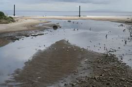 Photo 1.
|
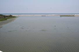 Photo 2.
| |
|
In the open condition, Photo 1, trains of gravels and
cobbles, lower right and left middle-ground, were deposited as stream velocity
was reduced. At still lower velocities, broad expanses of silts and sands were
deposited thereby giving the area the character of a mudflat. Bar channel
inlet and outlet are shown by arrows, right and left. Essentially the same
view, Photo 2, shows the closed condition giving the site its lagoonal
appearance. In it, a well developed strip of algae is exposed along the stream
shore, left. Views: south. Photos: EDM, 03/12/06 and 08/08/14, respectively.
Local hydrologic regimes of
special interest for present purposes are those concerning surface and
subsurface gains and losses - not their quantities for a given period - but
rather their different behaviors during open and closed conditions. During the
period of this study, which initially included about the latter four months of
an open condition followed, so far, by about six months of a closed condition,
the level in the lagoon project has fluctuated between about 2.4 and 7.4 feet,
NAVD888,
while maintaining near-constant elevations for periods of several days or
more. Such behavior implies incremental periods of closely approximating hydrologic
equilibrium when the sum of evaporation and subsurface outflow is nearly balanced
by subsurface inflow.
Comment
Generally, open and closed
conditions reflect different stages in the flow regime of Malibu Creek that in
turn responds to the hydrologic-equilibrium variables which themselves function
as regimes. In terms of biological concerns, the effect of the existing closed
condition that has persisted since about the middle of April, 2014, is essentially
disadvantageous, because as it progresses, the water quality deteriorates. With reference to the closed condition, Moffatt & Nichols staff (2005a, Sec.
3.1.1, p. 12) state:
"However, lagoon waters do not effectively
circulate when the mouth is closed, occurring roughly from May through October
every year (with variations depending on climate) (Sutula et. al, 2004) (Figure
7). Low dry season flows entering from upstream are unable to promote any
perceptible lagoon circulation because the lagoon is configured with the main
body as a broad basin that receives and dissipates any imparted current. Also,
vegetative growth within the lagoon reduces potential circulation, and shades
lower levels of the water column enhancing stratification ..."
Further, they conclude (op.
cit., p. 15):
"... This lack of lagoon circulation throughout
the warmest, high sun season can result in water stagnation leading to heating
and stratification (layering), retention of nutrients, and hypoxia (low oxygen
levels) or anoxia (no oxygen) in the water column (Sutula et. al, 2004; field
data collection by M&N and Heal the Bay as part of this study, 2004) ..."
These observations, made without
specific reference to the Tapia plant's restricted period of creek discharge,
and prior to the current drought, demonstrate the extent to which the current
closed condition is environmentally adverse.9
Regardless of such effects
however, it is the combined regimes of the bar formation and its breaching
channel that is most important for present purposes, because they determine the
character of the open condition and hence the extent to which tidal flushing
and circulation occurs in the study area. Tidal flushing and circulation, along
with holding capacity, were the three main goals of the lagoon project
projected by Moffatt & Nichol staff (2005a, p. 6),10
and thereafter specifically addressed by Moffatt & Nichol staff (2005b, Sec.
2.3, pp. 19-21) as part of the planned implementation. As noted by Tysor
(2010, III, 5A, p. 16), these objectives were to be incorporated in the final
plan prior to issuance of the project's coastal development permit according to
a detailed list of specific requirements (op. cit., III, 5A2, pp.
17-19).
In addressing the implemented project
design by Seville (2012) - which is entirely different from Alternative 1.5 of
Moffatt & Nichol - the Coastal Commission, according to Tysor (2010, IV.
A., p. 29) found that:
"...
The goal of the proposed restoration project is to increase circulation of
water in the lagoon during both open mouth and closed mouth conditions in order
to improve water quality and decrease eutrophication ..."
In support of
this, the Coastal Commission's issuance of the project's coastal development
permit required a "Final Hydrological Monitoring Plan" specifically
incorporating all the Moffatt & Nichol recommendations concerning a map of
sampling locations and nutrient sampling submitted on an annual basis in a
report with appropriate conclusions and recommendations regarding the level of
success of the project, all updated by bi-annual monitoring reports for a
period 5 years following project completion (op. cit., III, 5.A., pp. 16-19).
Further (op cit., p. 29):
"...If the
monitoring reports indicate that circulation within the lagoon has not improved
or has failed to meet the requirements specified above in B.1., the applicant,
or successors in interest, shall submit to the Executive Director, within 180
days of the date of the relevant monitoring report, a revised or supplemental
plan, certified by a registered engineer and a qualified Resource Specialist,
that specifies additional or supplemental measures to modify those portions of
the original plan that have failed or are not in conformance with the original
approved lagoon restoration plan..."
BAR SANDS MECHANICAL
CHARACTERISTICS
Littoral drift along the Malibu coast for thousands of years has resulted in the formation of sand bars at the
outlets of mountain streams. The largest of these - that at the outlet of
Malibu Creek - now attains a length of about 1,500 feet immediately east of the
Malibu Colony. At the time of the Rindge acquisition, it extended across the entire
shore of the creek floodplain, i.e., from Vaquero Hill west to what is
now the western end of the Colony. However, seawalls protecting Colony homes
now limit its function as a coastal bar.
It is unnecessary for present
purposes to dwell on the complex subject of coastal dynamics in order to
describe certain mechanical characteristics of the bar in detail. It suffices
here to note that despite the fact that beach sands along the Malibu coast commonly
recede offshore during winter months, such behavior is not characteristic of
the Malibu Creek barrier bar. During winter months when beaches, even as close
to the bar as that along Malibu Colony shore, may be almost completely denuded
of sands, the bar remains in place.
Such anomalous behavior
apparently is due to the manner in which ocean waves, both seas and swells, are
refracted as they approach the coast. As shown in a study prepared under the
direction of Peacock (1963, App. 1), the bar shore from Malibu Point11
to the Malibu Pier receives less wave energy than sections anywhere else along
the coast to the east. In theory at least, this appears to account for the
resistance of bar sands to offshore migration during winter months.
The transverse width of the bar
changes according to the effects of wave erosion as well as tidal changes and
shifting of the bar channel outlet. As a matter of speculation, once fully
formed, the bar width between the ocean and the impounded creek mouth shores
probably varies between 100 and 150 feet. In well developed cross-section, it
is lenticular with a crest close to horizontal and a base sloping seaward at a
low gradient. The maximum thickness along its crest probably is about five
feet.
It is obvious from casual
observations over many years that the bar crest never exceeds a certain
elevation and probably develops a slight gradient downward to the east. As
noted by Orme, (2000, Sec. 2.4.1.1, p. 2-50), during October and November,
1997, the bar elevation ranged from 2.5 meters in the west to 2.0 meters in the
east, i.e., between elevations 8.20 - 6.56 feet, NGVD2912
which they note is 0.8 meters above mean lower low water (MLLW). According to
NOAA's web edition of "Tides and Currents," mean sea level (MSL) and
MLLW are plus 6.652 feet and 3.827 feet (NAVD88), respectively, for Station
9410660, Los Angeles, giving a difference in elevation of 0.86 meters in close
agreement with that noted by Ambrose and Orme, et al. (ibid.).
Comment
The local littoral drift is a
very effective sorting mechanism.13
Seven grab samples collected from the bar on February 26, 2014 at depths of
about 1 foot and at intervals of 50 to 150 feet along its entire length were
found to be sub-angular to sub-rounded fine- to medium-grained sands. Close to
100 percent of each sample was in the range of 0.124 - 0.350 mm, fairly
consistent with the findings of Handin (1951, pp. 82 - 83) who found arithmetic
mean diameters for beach sands from Corral beach west of Malibu Creek of 0.320
mm and 0.5 mile east of Malibu Pier of 0.368 mm.
The strength of the bar sands is
a matter of some interest. The angle of internal friction of loose sand can be
approximated as its angle of repose, i.e., the angle the surface of a
carefully deposited conical pile of loose sand makes with horizontal. Generally,
it is found to be about 27 - 28 degrees. However, eroded banks of the Malibu
Creek bar-breaching channels can be as much as 2 - 3 feet high and stand close
to vertical. To investigate this, a dried 100-gram bar sand sample thoroughly
mixed with 100 milliliters of distilled water produced a decanted solution
having a sodium chloride (NaCl) concentration of 1,052 parts per million using
the standard Hach kit. This strongly suggests that the stability of the bar
sands in steep slopes along channel banks must be due to a certain degree of cohesion
apparently derived from NaCl, probably in combination with capillarity. Whether
the NaCl acts as a precipitated cement-like binder or induces cohesion due to
some sort of molecular attraction is uncertain.
Aside from being the most well
developed of some eight similar features14
along the Malibu coast, the bar at the mouth of Malibu Creek is important, because
it directly affects the manner in which the lagoon project can perform. Most
significant in this regard is the behavior of the breaching channel, and particularly
the elevation of its bed, because that directly controls the impounded water surface
elevation. In this regard, it is useful to consider a Hjulström diagram that demonstrates, in theory extensively
supported by experiment, whether grains of a certain size will, as a function
of stream velocity, either be carried in suspension or deposited as stream-bed
material. Figure 1, one of many found on the web, is one form of this type of
diagram.
The gray area in Figure 1
represents combinations of grain size and velocity where flow is more or less
turbulent because of local bed irregularities rather than higher in the stream
where it is essentially laminar. Along the beds of streams under such conditions,
it is common to observe "ripples," i.e., sequential ridge-like
structures with crests normal to the direction of flow and having gentler
slopes upstream and steeper slopes downstream.15 The red dotted lines added for present purposes in Figure 1 indicate the range
of bar-breaching channel velocities that cause the ripples commonly observed in
the beds of both active and abandoned channels.
|
 |
|
Figure 1. Malibu Creek Barrier-bar Texture in
Relation to the Hjulström Curve.
The Hjulström curve is the "Fall velocity"
line that separates grain sizes either carried in the flow or dropped from it
as a function of stream velocity. The area above the curve is separated into a
lower one in which grains are transported in suspension, in effect floating,
and above it, an area where grains are entrained in the flow by erosion. The
gray area represents a transitional zone where grains move along the stream
bed. It is in this zone that ripples develop in the bed sands.
By way of further explanation, the
samples collected for this review were from the crest of the bar. If such
samples were fed loosely in a bar channel stream, they would drop to the bed
where, as suggested by the gray zone in Figure 1, they would become part pof
the ripple mechanism.
BAR CHANNEL FLOW REGIME
Of the bar hydrodynamic regime
and its sub-regimes discussed in Part III of this review, it is sub-regime
[iii] concerning the manner in which the bar-breaching channel develops that is
especially relevant for present purposes. Prior to DPR acquisition, the
initial position of the channel inlet could develop naturally anywhere along
the inner bar shore. Breaching could be induced simply by impoundment overflow
due to stream inflow alone, or as a result of localized erosion of the bar
crest from the effects of high surf and tide, or perhaps by headward erosion in
the seaward bar face. Following DPR's acquisition, there was an uncertain
period during which artificial breaching was authorized by DPR management. Whether
this was accomplished simply by "notching" - i.e., grading a
narrow section of the bar at its western end16
lower than anywhere else along it so that overflow would begin there - or
actually physically excavating a channel across the bar, is uncertain. Once
flow began however, it would rapidly erode a channel through the bar to its
base, thereby exposing underlying cobbles and boulders previously deposited
during flooding.
The manner in which a stream
moves its bed material is of some interest for present purposes. As indicated
by Figure 1, the mode of transport of clasts of various sizes is directly
dependent on the stream's volume and velocity, the latter dependent on the bed
gradient. The classical description of such transport recognizes three stages:
"suspension" in the flow involving sands and finer-grained material, "saltation," essentially bouncing along the bed involving mostly coarser sands, gravels and
smaller cobbles, and "traction," essentially pushing and rolling,
involving larger cobbles and boulders. During flooding, all these modes of
transport occur. However, the evidence indicates that once the channel comes
into essentially equilibrium with drainage from the impounded area, bar channel
flow is clear of suspended load and the bed sands move essentially in traction
with little or no saltation.
Photos 3 - 8 show various stages
of bar channel development during an open condition with approximate tide and
project levels. Channels breaching the bar eventually develop a meandering pattern. In form, a meander is a set of paired features resulting from the tendency of a
stream to erode laterally. In this process, a curved channel develops which at
its outermost side the flow is deepest and its rate greatest. At its periphery,
a relatively steep bank is formed, while on the channel side opposite the flow
is shallowest and slowest so that bed materials are deposited there. These features
are referred to as a "concave bank" and a "convex bar,"
respectively.
Stream meandering is the subject
of a broad field of geologic investigation involving numerous combinations of
variables associated with the process generally. In the case of channels that
breach the bar at the mouth of Malibu Creek, however, the uniform texture and
virtual looseness of the bar materials, the fairly constant flow rate, and the
limited gradient between the impoundment and tide levels, reduce the process to
near-laboratory conditions. Under such conditions, as Friedkin (1945, p. 242)
has observed, "... the only requirement for meandering is bank erosion."
Consequently, although for
extended periods the flow rate17
remains essentially constant, the velocity varies according to the channel's
local cross-sectional geometry. Photos 3 - 6 show conditions prior to and soon
after breaching at the western end of the bar in November, 2013. Photo 6 shows
conditions when the channel is still almost directly normal to the shoreline
with its outlet just beginning to shift eastward. Photo 7, taken eighty-three
days later shows the channel passing in an easterly direction along the length
of the bar somewhat east of the bar mid-point. As shown in Photo 8, forty days
later, the channel had narrowed considerably with its outlet at the eastern end
of the bar, estimated to be about a week before actually closing.
Malibu Creek Bar Channel Inlet Site.
|
 Photo 3.
|
 Photo 4.
 |
|
|
The west end of the bar during a closed condition is
shown in Photo 3 where a previous breaching channel has been filled by
shoreline processes, project water elevation, 5.04 ft., NAVD88. Photo 4 shows
the inlet of a breaching channel believed to have developed about 11/15/13 showing
exposures of creek flood-plain alluvium, foreground, project water level, 2.72
ft., tide, 0.5 ft. Views: north and north-northeast; photos: EDM, 10/24/13;
11/29/13, respectively.
Malibu Creek Bar Channel Inlet Conditions.
|
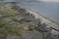 Photo5.
|
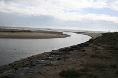 Photo6.
|
|
|
Photo 5 is a view upstream on the western side of the
bar-breaching that probably developed about November 15, 2013, when the Tapia plant
began creek disposal. Erosion has exposed darker fill over lighter bar sands. Photo 6, taken from the same location as that of Photo 5 shows the outlet of
the channel at the shoreline beginning to shift eastward. Approximate project
water level 2.72 ft.; tide, 0.5 ft. Views: north and south, respectively; photos:
EDM, 11/29/13.
Intermediate and Late-stage Bar Channel Conditions.
|
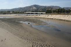 Photo 7.
|
 Photo 8.
|
|
|
Photo 7 shows a section of a broad meander about
midway along the length of the bar with the characteristic couple of a concave
bank about 2 - 3 feet high, right background, and a convex bar, left middle
ground. Note ripple marks, center middle and foregrounds. Photo 8 shows the
channel outlet within about a week of closing at the shore opposite the former
Adamson estate on Vaqueros Hill. The foaming, right middle-ground, is the
result of a standing wave created where the creek outflow and the tide inflow
meet; project water level elevation, 4.12 ft. NAVD88. Views: northwest and northeast,
photos: EDM, 02/20/14, tide, 2.9 ft.; 04/01/14, tide 4.3, respectively.
Comment
Development of the first open
condition affecting both the lagoon project and the impounded creek mouth to
which it is directly tributary was close to, if not actually coincident with,
the period of Tapia's permitted creek disposal period that began on November
15, 2013. The initial breaching channel inlet was at the western end of the
bar where a notch earlier had been graded. Once the initial energy due to the
relatively high impoundment elevation was eliminated, it appears that there
developed a bar channel flow rate that was essentially a function of the Tapia plant
creek disposal flow rate. As an example of this condition, according to data
provided by Dingman (2014b) for the period of January 1 - April 15, 2014,
discharge ranged between 0.13 - 10.45 million gallons per day (mgd) with and
average of 3.19 mgd and a median of 2.68 mgd. Assuming, simply for purposes of
discussion, that losses due to evaporation and subsurface outflow were equal to
subsurface inflow for the period in question, the range in the bar channel flow
rate would be 0.2 - 4.9 cfs. Bar channel flow rates observed during the period
of this review were well within this range.
Preliminary research suggests
that sequentially over time it is common for the bar to develop two or more
channel inlets. In such a process, if a new inlet develops east of an earlier
one, they will become confluent. An example of such a condition is shown in
Photo 9.
Prior to breaching, area a was
the aggraded bed of the impoundment. The encircled area is evidence of the
irregular manner in which breaching can occur to wit: [1] development of
an earlier breaching channel inlet to the west, not shown, having a well
developed bed of aggraded sand bar deposits, b; [2] initiation of breaching by channel s
stream carving banks c and d, initiating convex bar e deposits,
and reaching confluence with the bed b
stream; [3] temporary renewed flow of bed b
stream eroding a section of bank c (encircled); [4]
termination of the flow of the bed b stream
apparently due to aggradation at its inlet; [5] continued but diminished flow
of the channel s stream
taking into suspension b
deposits and carving a lower concave section of bank d coincident with enlargement of convex
bar, e; [5] high tide
encroachment bringing upstream strands of Macrocystis pyriphera,
"giant kelp," common along shores in Malibu, the channel islands, and
elsewhere in southern California.
|
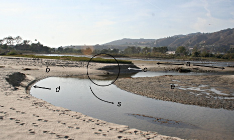 |
|
Photo 9. Bar Channel Inlet, Advanced Stage of Breaching Process. |
|
Earlier aggraded areas include: a - the aggraded bottom of the impounded area prior to
breaching; b - the channel bed of an earlier breaching stream.
Later channel features include: c - initial concave
bank of s channel, d - concave bank of s channel;
e - convex bar associated with d. Note ripples in the active channel around patch of
kelp lower right, washed in from previous high tide. See text regarding the encircled
area; project water elevation, 4.09 ft., tide: 2.7 ft. View: northwest. Photo:
EDM, 02/20/14.
The late-stage open condition
indicated by the position of the bar channel outlet as observed on April 1 and
shown in Photo 8, had ended well before May 8, and probably on or very soon
after April 16. Since according to Dingman (op. cit.) Tapia plant creek
disposal ended on April 15, it seems certain that the closure occurred more or
less in direct response. Also, initiation of the forthcoming open condition in
direct response to plant creek disposal scheduled to begin on November 15 seems
likely. In any event, the extent to which these relationships are
drought-related is yet to be determined.
BAR CHANNEL AGGRADATION
"Aggradation" is the
process by which the bed of a stream rises in response to receiving deposits in accordance
with the mechanism illustrated in the Hjulström diagram. The expanse at a
in Photo 9 is the aggraded bottom of the impounded area that became exposed when the bar was
breached. Aggradation can occur along the reach of any stream due to a local reduction in gradient
or when it reaches a base level such as a lake or the ocean. Generally, floodplains such as that
at the mouth of Malibu Creek are a result of aggradation along streams that feed them.
Observations over a period of
months indicate that flows in channels through the bar at the mouth of Malibu
Creek soon after breaching are free of suspended load. The flow is great enough
to move the bar sands in traction sufficient to for bed ripples and this
combination of flow rate and bed sand texture is characteristic of the bar's
breaching channels. Because of meandering and bar sand weakness, caving of the
concave bank results in widening and reducing the depth of the channel. However,
at the bar's eastern end, massive rip-rap along the shore at Vaquero Hill restricts
further shifting of the bar outlet in that direction while the littoral drift
mechanism continues to operate eventually closing the bar outlet.
Comment
It is useful to consider the
relationship of physical equilibrium in relation to aggradation. Generally,
equilibrium implies some sort of balancing. Unlike hydrologic equilibrium
which implies balancing volumes of water under various conditions, physical equilibrium
involves a balance of forces. If the masses are stable, static equilibrium
prevails, and if they are in motion, dynamic equilibrium tends to develop. In
the case of a bar channel stream, a condition of limited dynamic equilibrium
occurs along the bed itself where the motion of the water is resisted by the
bed sands. The pervasive trains of ripples common along channels breaching the
bar at the mouth of Malibu Creek represent, within the limits of velocity and
grain size, a condition of dynamic equilibrium.
For present purposes, it is especially
relevant to note that this condition of limited dynamic equilibrium requires
that at its inlet the aggraded channel bed remains essentially stable at a
particular elevation. In other words, most of the time during the open condition,
the inlet of the bar channel has a close to constant elevation subject to, and
only slightly less than, elevation changes in the surface of the creek mouth
impoundment which, in the absence of excessive rainstorm runoff, occur only gradually. The extent to which aggradation of the bar channel is
affected by tides is uncertain, but the elevation to which the impoundment
surface is raised by incoming tides cannot be great considering the limited
width of the channel and the relatively large impoundment.
References
Abramson, Mark, Rosi Dagit,
Dan Cooper, Jaime King, Ivan Medel, and Charles Piechowski, 2013, Malibu
Lagoon restoration and enhancement project comprehensive monitoring report:
Santa Monica Bay Restoration Foundation rpt. for State of California, Department
of Parks and Recreation, March 19.
Ambrose, Richard F., and
Anthony R. Orme, 2000, Lower Malibu Creek and lagoon resource enhancement and
management: Univ. Calif. Los Angeles, special study for California Coastal
Conservancy.
Dingman,
Brett, 2014a, Tapia plant discharge schedule: e-mail communication, April 29.
____________, 2014b, Attachment re Tapia plant discharge,
fish flow; 2007 guidelines to maintain minimum flow: e-mail communication,
September 12.
Friedkin, J.F., 1945, A laboratory study of the
meandering of alluvial rivers: rpt. of U,S. Waterways Experiment Station, Vicksburg, Miss., U.S. Army Crops of Engineers, May 1.
Handin, John W., 1951, The source, transportation and
deposition of beach sediment in southern California: PhD thesis, Dept. Geology,
Univ. Calif. , Los Angeles, published as Technical Memorandum No. 23, Beach
Erosion Board, U.S. Army Corps of Engineers, March.
Moffatt & Nichol staff,
2005a, Malibu Lagoon restoration feasibility study final alternatives analysis:
Moffatt & Nichol in association with Heal the Bay rpt. for California State
Coastal Conservancy & California State Parks, March.
Moffatt & Nichol staff,
2005b, Final Malibu lagoon restoration and enhancement plan: Moffatt &
Nichol in association with Heal the Bay rpt. for California State Coastal
Conservancy & California State Department for Parks and Recreation, July
17.
Orme, Antony, Kenneth
Schwarz, Priya Fennemore, Mark Khulman, and Johannes Feddema, 2000, Hydrology
and morphodynamics, Ch. 2 in Ambrose and Orme (2000), pp. 2-1 - 2-112.
Peacock, Earl G., Col., Dist.
Engineer, 1963, Cooperative beach-erosion investigation, Malibu-Santa Monica
area, California: U.A. Army Corps of Engineers feasibility study of proposed marine
locations for State Highway Route 60 and their shoreline effects for
California Water Resources and Dept. Public Works, Div. Highways, August.
Seville, Steven R., 2012, Malibu Lagoon State Beach
Restoration and Enhancement - Phase 2: ICF International, 51 sheets, June 30.
Stone Environmental, Inc.
staff, 2004, Risk assessment of decentralized wastewater treatment systems in
high priority areas in the city of Malibu: Stone Environmental, Inc. study,
Stone Proj. No. 011269-W, for Santa Monica Bay Restoration Commission and California State Coastal Conservancy.
Sutula, Martha, Krista
Kramer, and Jaye Cable, 2004, Sediments as a non-point source of nutrients to
Malibu Lagoon, California: Southern California Coastal Water Research Project Tech. Rpt. #441, final report to LARWQB, November 1.
Tysor, A., 2010, Summary of
staff recommendation: California Coastal Commission Staff Report: Regular
Calendar, Item W6a re App. No. 4-07-098, September 29 (Hearing Date: 10/13/10).
Valor, Scott, Director, 2014,
E-mail response to E.D. Michael re SMB Restoration Foundation activities: Santa
Monica Bay Restoration Commission, September 26.
END PART IV.
8
Henceforth, where reported, project water
elevations are for the North American Vertical Datum of 1988 (NAVD88), as inscribed
on a survey monument set in the top of the curb at the WOP (see Part III, Fig.
7) reading "El. 6.87 NAVD88," and hereinafter taken as fiducial.
|
| |