| |
|
ENVIRONMENTAL LESSONS
of the
MALIBU LAGOON PROJECT
A Review of the Record
E.D. Michael
March 11, 2014
|
INTRODUCTION
This review of the Malibu Lagoon
project is presented as an object lesson illustrating how an ostensibly well-planned
environmental project can fail despite engendering from its inception
widespread community approval, ratification of various public agencies mandated
to protect or improve the environment, and technical assurances of feasibility.
First, it analyzes the record
concerning, successively, the project in terms of its prehistoric and historic antecedents,
the environmental milieu from which it was conceived, its
planning and approval, its construction, and its performance, each followed by
comments adding to or modifying that record. Second, it discusses the extent to which the project has failed and the
reasons for it. And third, it offers
recommendations regarding how failures of similar projects might be avoided.
MALIBU LAGOON PROJECT
PURPOSE AND RATIONALE
The announced purpose of the Malibu lagoon project was
to "restore" and "enhance" part of the mouth of Malibu Creek, widely
regarded as an oceanic coastal lagoon. The creek mouth on its western side had been modified by grading probably
for agricultural purposes late in the 19th century, covered with artificial
fill during the late 1920s while under private ownership, and after coming
under the control of the California Department of Parks and Recreation (DPR),
regraded in 1983 with channels on the assumption that this would result in
restoring lagoonal conditions and desirable natural habitats. The present lagoon project was undertaken to replace
the 1983 channels with others intended to increase circulation thereby greatly
reducing or eliminating hypoxia and generally improving habitat
conditions.
SCOPE OF REVIEW
This review concerns only
physical aspects of the project It
remains for others to address its ramifications regarding: [i] its asserted
relation to the area's natural ecologic character, especially in terms of so-called
endangered species; [ii] its recreational aspects; [iii] the legality of its
environmental approval; and [iv] an accounting of funds, all far beyond the abilities of this poor
scrivener. Nevertheless, even without attention to such weighty matters, the
subject requires a rather lengthy treatment. Hence, it is presented here in six serial installments. These are: Part I - Floodplain Prehistoric Conditions;
Part II - Lagoon Project Site History; Part III - Environmental Planning and Approval;
Part IV - Lagoon Project Construction; Part V - Lagoon Project Performance;
Part VI - Conclusions Although for some
readers the serial format can be frustrating, I make no apology. If it was good enough for Sir Arthur Conan
Doyle, Henry James, Harriet Beecher Stowe, and Herman Melville, it's good
enough for me.
Part I - FLOODPLAIN PREHISTORIC CONDITIONS
The Malibu Lagoon project lies at
the south-easternmost part of the Malibu Creek floodplain. The character of the project cannot be fully
understood without reference to the floodplain itself and the prehistoric period
during which it developed.
ANTECEDENT CONDITIONS
Malibu Creek passes entirely
through the Santa Monica Mountains as a superposed
stream, i.e., a stream that has
maintained its course during a change in the conditions with which it
originally was in equilibrium In this
respect, it is unique in California. The rise of the Santa Monica Mountains block is believed to have begun about a million years before the present (ybp)
during the Pleistocene Epoch considered to have begun about 2.6 million
ybp Then, much of the area from which
the block began its rise had become an erosional surface of low relief and to some
extent an emerged Late Tertiary sea bed. A small part of it was drained by ancestral Malibu Creek - a stream that
meandered to the ocean through an area that now includes Thousands Oaks, Calabasas,
Agoura Hills, and part of the Simi Hills. The rise was so slow that the creek was able to maintain and deepen its meandering
course through the rising block As the
block rose, the creek was rejuvenated so that erosion of its thalweg kept pace
with increasing elevation Once shallow
meanders eventually became the deep gorges now called Goat Buttes and at what
is now Serra Retreat In that process,
ancestral Malibu Creek lost forever the meander-forming mechanism of
stream-bank cutting and filling. Downstream from the Serra Retreat meander, it
can only be assumed that similar conditions prevailed. In effect, ancestral Malibu Creek became a youthful
stream in response to the steepening mountain block gradient while retaining
its old-age configuration to the Pleistocene shore some distance, perhaps a
mile or more, farther south than today.
Comment
This condition should have
prevailed until the beginning of the Wisconsin
glacial episode about 85,000 ybp at which time lowering sea level added
additional energy to that due to tectonic uplift. It is inferred that the lowering sea level
infused the reach of ancestral Malibu Creek closest to the shore with energy
sufficient to introduce locally consequent stream erosion. It is postulated that in the 73,500 years following
the beginning of Wisconsin glaciation the area
from some point downstream of the Serra Retreat meander was transformed to a
youthful terrain Similarly, elsewhere along
the Pleistocene Malibu shore, consequent streams developed ancestral to the master
streams of today from Topanga Canyon west to Little Sycamore
Canyon.
FLOODPLAIN DEVELOPMENT
Beginning about 19,000 ybp, the Wisconsin glacial episode began to wane and sea level
world-wide began rising due to glacier melting. The resulting landward advance of the sea,
called the "Flandrian transgression"
caused shoreline streams to begin aggrading.
In particular, it is inferred that ancestral Malibu Creek in very late Pleistocene
time began this process of aggradation, and that by about 11.5 thousand ybp, at
the beginning of the interglacial episode called the Holocene Epoch, it was
well advanced Since then - with
possible retrograde periods when local tectonic and/or isostatic increments of
rise briefly offset sea-level rise - aggradation has continued. Most important for present purposes, this
model postulates that the present extent and shape of the Malibu Creek floodplain
is entirely in response to the processes of stream clogging and lateral
planation that invariably accompanies stream aggradation.
Certainly within the first half
of the Holocene Epoch and possibly as early as latest Pleistocene time, flow from ancestral Malibu
Creek entered the floodplain from the lowermost reach of the superposed Serra
Retreat meander along which Mariposa de Oro in the Serra Retreat area now is located
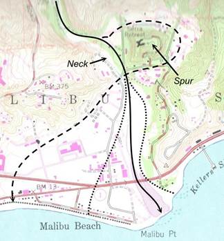
as shown in Figure 1. From near what is now the
|
 |
|
Figure 1. Malibu Creek Holocene Floodplain Stream Regimes.
Dashed and solid lines approximate earlier
and later creek regimes, respectively. Dotted lines indicate the approximate predevelopment boundaries of the
later creek floodplain "Spur"
and "Neck" refer to the basic structural characteristics of the Serra
Retreat meander. Base: U.S.G.S. 7.5-minute
Malibu Beach quadrangle, ed. 1981, as modified.
Cross Creek bridge,
just west of the intersection of Mariposa de Oro and Cross Creek Road, the creek flowed on to
the aggrading floodplain in a southerly direction along the base of the Malibu
Knolls slope and past the mouth of Winter Canyon to the shore near
what is now the western end of the Malibu Colony. Probably as late as 1945, the mouth of that
stream, blocked by a barrier sand bar, was a body of water that at least as
early as 1916 was called "Malibu Lake." Probably it persisted into the early 1940's. A remnant of that feature exists today some
500 to 1,000 feet west of Stuart Ranch Road and just north of the massive highway
fill as the only true natural wetland in the Malibu Creek floodplain -
excavated depressions in the entirely artificial Legacy Park notwithstanding.
Probably in
the latter half of the Holocene Epoch - say 3,000 or 4,000 ybp - ancestral
Malibu Creek broke through the neck of the Serra Retreat meander in a manner
yet to be understood The resulting isolated spur became the
promontory that one day Frederick Rindge (1892, p. 70) was to call
"Wunderschön
Vista Ridge" and now is the site of Serra Retreat. As a result, Malibu Creek abandoned its southwesterly
reach in favor of a direct southerly one. Probably, that event did not change significantly the position of the
shore which extended then from Vaquero Point on which the Adamson House now is
located to near what is now the western end of the Malibu Colony. Figure 1 illustrates these two stream regimes
and their geomorphic origins. It is to be understood that although both
occurred in Holocene time, the Serra Retreat meander itself is essentially a superposed
Pleistocene feature Although modified
to some extent by Holocene stream erosion, it required many thousands of years
prior to the Holocene to broaden and deepen it to its basic configuration.
Comment
It is
necessary for present purposes to rationalize the available subsurface floodplain
data from Bausch, et al. (op.cit.) with what has come to be known
as the "UCLA study" by Ambrose and Orme (2000) which, inter alia, interprets the Malibu Creek
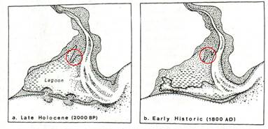
floodplain during the past 2,000 years as having been mostly a lagoon. Accordingly, (op. cit, pp. 2-1 - 2-2), Figure 2-1a of Figure 2 represents conditions
about 2,000 ybp.
|
|
|
Figure 2. UCLA Study Figure 2-1a, b).
Short
dashed lines presumably indicate finer-grained lagoonal deposits and dotted
areas coarser-grained floodplain deposits. The red circles have been added to indicate the general location of the
"Sycamore Grove" - see note (2) below.
To better
understand this interpretation, the following quotation (op. cit., p. 2-2) is cited to which has been added numerals for subsequent discussion:
"... The present estuarine lagoon came
into existence towards the end of the Flandrian transgression culminating in a
reduced but continuing rise of relative sea level of about 1.8 mm per year
during late Holocene and, as revealed by tide-gauge records since 1933,
historic times A reconstruction of the
late Holocene estuarine lagoon some 2,000 years ago, based on field investigations
and comparable analogs (1), is presented in Figure
2-a At the time, Malibu Creek spilled
from its bedrock narrows upon to a fan delta, at time flooding the entire apex,
at other times incising its own deposits to leave a floodplain terrace which
survives above the inner margins of the lowland, subject to inundation during
unusually high magnitude floods (2). Farther downstream, the creek meandered through its estuarine lagoon (3),
but was pushed eastward by the onshore and downdrift construction of a low
barrier beach (4). The greater part of
the lagoon to the west (5) gradually, if erratically,
filled with backwater sediment, occasionally flood deposits, colluvium and
alluvial fan deposits from the adjacent hill slopes, and flood-tidal deltas and
overwash through and across the still incomplete barrier beach (6). With a larger tidal prism than today, channels
through the barrier were maintained for a while by outflowing lagoon waters and
the consequent formation of ebb-tidal deltas (7)."
(1)
- By "field investigations" presumably is meant, primarily, the work
of Bausch, et al. (op. cit.), supplemented by three borings
for the UCLA study, but whether by "analog" is meant: [i] coastal
floodplain depositional conditions elsewhere, or [ii] the presumption of a
similar earlier climatic cycle, or both, is uncertain. However, the idea that up until about 200
years ago there had been a period of at
least 1,800 years during which there prevailed the low-energy stream condition
that a floodplain-wide lagoonal condition requires, is directly controverted by
the available evidence, as discussed below.
(2)
- If by "floodplain terrace" is meant the surface of deposits exposed
after flooding, there are two in the
vicinity of the Malibu Creek floodplain. One is at its eastern edge where a mass of alluvium traversed by Serra Road is
deposited on a coastal platform at about elevation +80 feet msl carved in the
Trancas Formation as mapped by Yerkes and Campbell (1980). Flooding of that area clearly has not occurred
during historic time The other is uncertain
since the surface at the floodplain's northwestern edge at about +25 feet msl
descends more or less uniformly to the northern edge of the barrier bar which,
except where breached, defines the southern edge of the floodplain. The earlier
stream regime of Figure 1 seems to have been ignored in the UCLA study and
suggests that Figures 2-1a and 2-1b of Figure 2, instant, were intended to be
essentially diagrammatic. It is to be noted, however, that the protrusion
encircled in Figure 2 corresponds to a relatively coarse mass of floodplain
alluvium which supports tree growth that Frederick Rindge (1898, pp. 73 - 85)
unreservedly admired and enjoyed which he called "The Sycamore
Grove."
(3)
- There is no evidence of a meandering stream channel in the Malibu Creek floodplain,
and the term "estuarine lagoon" in geologic parlance is a non sequitur. An "estuary" is a partly enclosed
relatively deep coastal inlet such as a fjord freely open to the sea. Its use to describe a coastal lagoon which is
essentially a landlocked feature tributary to the sea only through one or more
shallow tidal channels is to be discouraged.
(4)
- It is important to understand that the eastward-shifting of the channel
breach in the shoreline barrier bar is not "pushed," which implies a
direct application of some sort of force. Rather it is the result of the interaction of: [i] more or less
continual clogging at the mouth of the breaching channel at its western side,
with [ii] east-moving littoral drift, and [iii] the breaching channel flow
rate This mechanism is entirely
independent of the pattern of flow upstream.
(5) -
As previously discussed, the idea of lagoonal
conditions over most of the Malibu Creek floodplain in the late Holocene - or at any time - is simply
speculation The western side of the
floodplain was carved by erosion and lateral planation of the southwesterly
directed stream regime There is no evidence
that the western side of the floodplain was essentially a
lowland subject to filling in late Holocene time.
(6) - The idea of a "still
incomplete barrier beach" in late Holocene time is inconsistent with the existence
of the postulated widespread lagoon shown in Figure 2-1a, the mere presence of
which would require a well developed barrier bar. Barrier bars along the Malibu coast are essentially a function of
wave approach and stream deposits at the shore. They are quite common and well- developed at the mouths of the Arroyo
Sequit, Trancas Canyon, Zuma Canyon, Corral Canyon, and Topanga Canyon. There is no evidence upon which to postulate an incipient condition of
barrier bar formation at the mouth of Malibu Creek 2,000 ybp. Such bar formation is a result of stream
aggradation and wave approach along the Malibu coast - a condition that began to develop with advent of the Flandrian transgression
and persists today
(7) -
The record does not support the
idea of a "larger tidal prism" by which presumably is meant a larger
volume of lagoonal waters in Holocene time up to 1800 AD as Figure 2-1a of
Figure 1 requires Observations such as
this and "ebb-tidal deltas" seem to have no purpose other than to
support a postulated floodplain-wide lagoonal condition which
in the absence of any evidence whatsoever is simply speculative.
FLOODPLAIN SUBSURFACE CONDITIONS
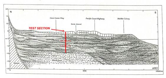
Figure 3 reproduces
Figure 1-8 of Ambrose and Orme (2000, p. 1-16) for the UCLA study. Apparently, it is based largely on data from Bausch,
et al. (op. cit., App. B and C) which include the logs of cores from six
borings and data from two lines of cone penetrometer tests (CPTs). Their data were supplemented by three additional
core logs obtained as part of the UCLA study effort. It is to be noted that the investigation by Bausch, et al.
(op, cit.) was for the purpose of determining the extent to which
conditions such as faulting, foundation-bearing capacity, and liquefaction
might affect development rather than to investigate lagoonal or other environmental
conditions.
|
|
|
Figure 3.UCLA Study Figure 1-8, Modified.
This figure is a generalized north-south
cross-section through the Malibu Creek floodplain from Anthony and Orme (2000,
Fig. 1-8, p. 1-16). "Fluvial
gravel" apparently is the "Civic Center gravels" as
discussed by Bausch, et al. (1994). The dotted lines in the TEST SECTION bracket
a radio-carbon dated interval of 6,500 - 7,850, ybp. Vertical exaggeration:
10X.
Generally, CPT
data describe mechanical conditions. They do not provide any direct lithologic information and have value for
inferring such only if related to lithologic logs from nearby borings. Of the six cores obtained by Bausch,
et al. (op. cit., App B) which range in depth from 43.5 to 55 feet, only
LB-4 encountered organic materials that might be indicative of a lagoonal
environment, and it was located at the abandoned mouth of the earlier Holocene
stream regime shown in Figure 1 This,
and data derived from three cores obtained specifically for the UCLA study,
apparently provide the only basis for its Figure 1-8, reproduced here as Figure
3 Detailed discussion of these latter
three cores (Ambrose and Orme, 2000, pp., 1-15 - 1-20) is essentially an
interpretation of alternating fluvial and organic-rich deposits in the range of
-1.5 to - 47.7 feet msl supported by reports of scattered plant remains
consistent with both fresh and brackish water conditions, and ranging in age
from 1,660 - 9,470 ybp From these data,
the opinion is offered that they are consistent with Figure 1-8 of Figure 3 as
well as another in an east-west direction not reproduced herein.
The general
locations of relevant data sites regarding subsurface investigations in the
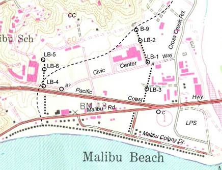
Malibu Creek floodplain are shown in Figure 4. Bausch, et al. (op. cit., p. 21) note that from boring
B-9 in the "Knapp-Marlin" property, GeoSoils collected two charcoal
samples between depths 19.0 and 19.5 feet and 25.0 and 26.5 feet that yielded
radiocarbon dates of 6,500 ±130
ybp and 7,850 ±100 ybp,
respectively. Although not entirely
clear, it appears from Bausch, et al.
(op. cit., Pl. 1) that the elevation
of the B-9 boring site is at about +23 feet msl.
|
|
|
Figure 4.Subsurface Data Sites - Malibu Creek Floodplain.
LB borings 1 through 6 and GeoSoils boring
B-9 are discussed by Bausch, et al. (op. cit., Pl. 1). The dashed line is the approximate northwesterly
edge of the floodplain. The coarse dotted lines, not to be confused with the
line of houses along Malibu Colony Drive, indicate, diagrammatically, lines of CPTs. A, B,
and C are locations of three borings
specially drilled for the UCLA study A
is very close to LB-1 The location of B
is uncertain LPS and CC indicate the
locations of the Lagoon project site and Malibu City Hall. Base: USGS 7.5-minute Malibu Beach quadrangle, ed. 1981, as modified.
Ignoring the
date error ranges - the averaged 6.5-foot section between the reported depths of
19.0 feet and 26.5 feet in boring B-9 was deposited during a period of about
1,350 years giving a depositional rate of about 1 foot per 208 years. Thus, it would have required 780 years to raise
the elevation of the floodplain at B-9 an average distance of 3.75 feet to the present
surface at elevation +23 feet msl. Because B-9 is located along the reach of the southwesterly creek
regime, this datum indicates that at least as late as 6,500 ybp the
southwesterly flow regime of Malibu Creek prevailed. Consequently, taking the
period of the Holocene to be 11,500 years, the incision of the meander neck that isolated the Serra
Retreat spur must have occurred within the past 5,000 years.
Comment
Neither the data from Bausch, et al. (op. cit.)
nor the cores for the UCLA study provides a sufficient basis
for the lithologic detail of Figure 3 That
the subsurface data are considered "consistent" by Ambrose and Orme (op. cit., p. 1-20) with the figure can
mean nothing more than that it depicts one of an infinite number of ways that
subsurface conditions might exist in the floodplain; in fact, it is simply an
artistic rendering Furthermore, the
data support neither the contact of "Fluvial gravels" vis-a-vis the overlying "Fluvial
sand," etc., nor their
horizontal and vertical distributions. In other words, whatever the GeoSoils logs of borings may show, those of
Bausch, et al. (op. cit., App. B) demonstrate simply that the mass called the
"Civic Center gravels" has a preponderance of sandy gravels recognizable
at certain locations below a depth of about 50 feet, but by no means do they demonstrate
the lateral or vertical lithologic continuity shown in Figure 2. Furthermore, although the depths of LB-1
through LB-6 ranged between 43.5 and 51.5 feet, only the log of LB-4, drilled
in the wetland of what was once "Malibu Lake"
reports significant organic material
Most likely, the transition of the
Civic Center gravel mass to the overlying "estuarine materials ... deposited
beginning approximately 15,000 years ago and continuing to about 2,000 years
ago..." as asserted by Bausch, et al.
(op. cit. , Sec. 5.1.4, p. 21), is
the result of a decreasing rate of sea-level rise during the later stage of the
Flandrian transgression Furthermore, disparate
occurrences of "estuarine" materials at depth lacking any evidence of
lateral continuity provide no basis whatsoever for postulating a lagoonal
condition over the floodplain during the Holocene epoch nor at any other time.
CONCLUSIONS
The available
subsurface data are insufficient to demonstrate that actual lagoonal conditions
persisted over most of the floodplain as late as 1,800 ybp during which
low-energy stream conditions would have to have prevailed. If that were true, it would mean that somehow,
since 1800 AD, the local area suddenly became the site of its present
high-energy stream depositional character to account for alluviums with upper
surfaces now in the range of +10 - +20 feet msl, well above the surface elevation
of any tidal lagoon postulated to have existed a mere 200 hundred years
previously Consequently, such a
postulate cannot be seriously considered. While an opinion of "... episodic wetlands throughout the
Holocene..." (op. cit., p. 1-19)
seems justified, the data do not support the idea of
an area-wide lagoon in the Malibu Creek floodplain at any time.
The
floodplain-wide lagoonal thesis of the UCLA study may have been presented simply
in support of the study's primary purpose which was to investigate existing
conditions in order to "... understand better the natural system and human
impacts on this system, and to develop strategies for the long-term management
of the lower watershed ..." (op. cit, p. iv) To that end, the UCLA study has
much to offer With regard to planning,
however, renderings such as Figures 2 and 3, per se, could have played a significant role in the minds of Malibu
Lagoon project planners as ostensibly confirming the idea of a lagoon at the
mouth of Malibu Creek suitable for restoration. To the extent that today's community of environmental shakers and movers
regard restoration as very important, if not the sine qua non, of project funding, it is a matter of significant concern
that the Malibu Lagoon project came to be implemented even though it has no
such antecedent character.
References
Ambrose, Richard F., and
Anthony R. Orme, 2000, Lower Malibu Creek and lagoon resource enhancement and
management: Univ. Calif. Los Angeles,
special study for California Coastal Conservancy.
Bausch, Doug, Gan Mukhodhyay,
and Eldon M. Garth, 1994, Report of geotechnical studies for planning purposes
in the Civic Center area, City of Malibu, California: Leighton and Assoc., Inc. rpt., Project No. 2920647-01 for Malibu
Village Civic Association, March 18.
Rindge,
Frederick Hastings, 1898, Happy Days in Southern California: The Riverside
Press, Cambridge, Massachusetts and Los Angeles, California,
reprinted by KNI, Inc., Anaheim, CA, 1984.
Yerkes, R.F., and
R.H. Campbell, 1980, Geologic map of the east-central Santa Monica Mountains,
Los Angeles, County, California; U.S. Geol. Survey Misc. Inv. Series Map
I-1146
* * *
|
| |